Geospatial Information Authority of Japan
Territory of Japan
Geospatial Information Authority of Japan (GSI) determines the location of territory of Japan on Earth by means of surveys, and develops maps that clearly show the territory.
Provision of maps clearly showing territory of Japan
GSI develops several kinds of scaled maps of the entire territory of Japan, including detailed "1:25,000 topographic map".
Also, in order to ensure that territory of Japan is accurately understood both within Japan and overseas, we have developed a map that condenses the whole territory onto a single sheet entitled "1:5,000,000 map of Japan and its surroundings" (Japanese and English versions are available).
Everyone can view and obtain these maps that GSI has developed through GSI homepage or in general bookstores, etc.
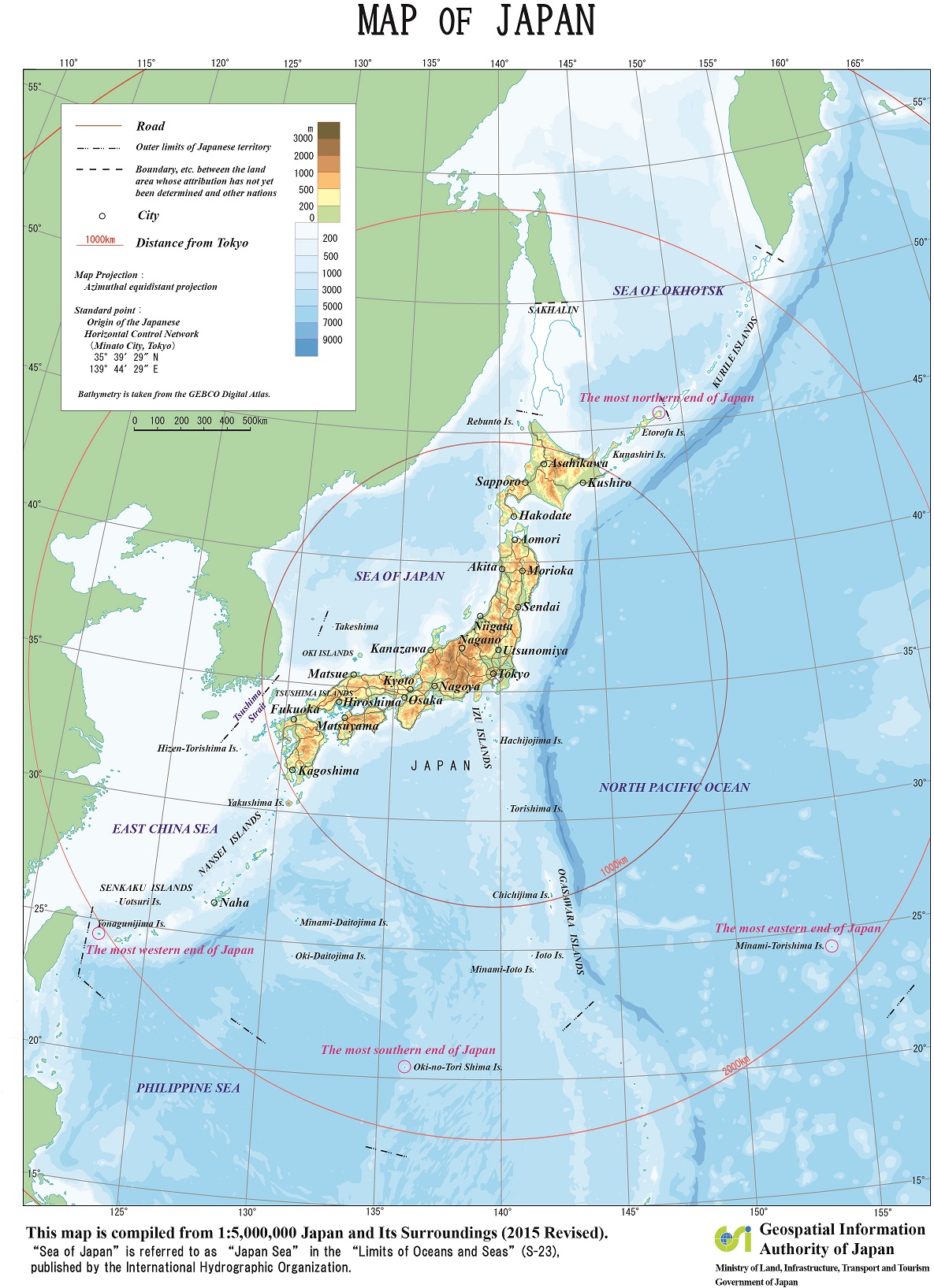
Territory of Japan 377,974.87 km2 (As of April 1 2026)
Standardization of Names of Japanese Islands in English
The following are the principles for standardization of names of Japanese islands in English as approved in "the Interagency Coordination Group on Communications Concerning Territorial Integrity" held on March 11, 2014.Geospatial Information Authority of Japan (GSI) creates maps or gazetteers in English in conformity with these principles
Principles for Standardization of Names of Japanese Islands in English
The names of Japanese islands in English are to be composed of "the island's name (Japanese names in Roman characters notation)" and "Island". However, this does not apply when another English name is in use in treaties or other official documents.
【Notation examples】
大島(おおしま) Oshima Island
新島(にいじま) Niijima Island
The following are examples of islands' names which are already used in treaties or other documents. Other examples are to be added in the future.
【北方領土】 The Northern Territories
択捉島(えとろふとう) Etorofu Island
国後島(くなしりとう) Kunashiri Island
色丹島(しこたんとう) Shikotan Island
歯舞群島(はぼまいぐんとう)Habomai Islands
【竹島】 Takeshima
【尖閣諸島】 The Senkaku Islands
魚釣島(うおつりしま) Uotsuri Island
北小島(きたこじま) Kitakojima Island
南小島(みなみこじま) Minamikojima Island
久場島(くばしま) Kuba Island
大正島(たいしょうとう) Taisho Island
沖ノ北岩(おきのきたいわ) Okinokitaiwa Island
沖ノ南岩(おきのみなみいわ)Okinominamiiwa Island
飛瀬(とびせ) Tobise Island
Standardization of Names of Japanese Islands in English
http://www.gsi.go.jp/ENGLISH/kihonjyoho-e31000.html
Links

"GSI Maps" is a service provided by GSI that users can browse maps and aerial photographs, etc via website
Users can browse maps and aerial photographs developed/taken from the past up to the present, including "1:25,000 topographic map" and a "1:5,000,000 map of Japan and its surroundings", etc.
It is possible to obtain a complete map of Japan in A4 size developed from the "1:5,000,000 map of Japan and its surroundings".