The documents and materials published on this website were collected, researched, and prepared with advice from experts, as a part of a Government-commissioned project. The contents of this website do not reflect the views of the Government. Links to external sites (domains other than https://www.cas.go.jp) are not under the management of this site. For linked websites, please check with the organization/group that manages the website for the link in question.
Analysis of claims by other countries
(2) References to “Diaoyu Tai” in A Tour of Duty in the Taiwan Strait
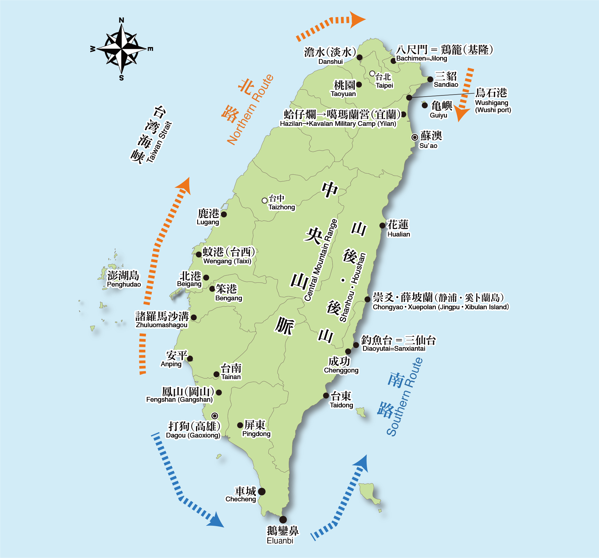
Huang Shujing goes on to describe the problem of stowaways from Fujian and Guangdong to Taiwan, which contributed to worsening public security in Taiwan(→Material 5). Since stowaways often boarded smaller ships on the mainland side and then moved to larger ships, Huang Shujing argues that the key to solving the problems of stowaways and worsening security in Taiwan was the strengthening of port controls both on the mainland and Taiwan sides. Subsequently, in the book, the names of Taiwan's nearshore and coastal ports are enumerated according to the capacity of entry in terms of the size of ships, counter-clockwise on the South Route as well as clockwise on the North Route, starting from an area around today’s Tainan and Kaohsiung (see Figure).
It is in this list of ports that the place name of “Diaoyu Tai” appears.
In it, as ports with the capacity for the entry of a large patrol ship with a keel, Luermen (west of Tainan) and Takau Port (Kaohsiung City) on the South Route, and Wengang (Taisi Township, Yunlin County), Bengang (Beigang Township, Yunlin County), Danshui [澹水] (Tamsui [淡水] District, New Taipei City), Xiaojilong (Sanzhi District, New Taipei City), and Bachimen (Keelung City) on the North Route are listed.
The largest number of ports listed there are those with the capacity for the entry of sampan boats with a shallow bottom and other smaller ships. Of those, for the South Route, ports facing the Taiwan Strait from Fongshan Dagang (Kaohsiung City) to Houwanzai (Checheng Township, Pingtung County) and inland river ports are enumerated in order; for the North Route, coastal ports from Zhuluo Mashagou (Tainan City) via the northernmost Danshui and Jilong to Hezailan (Yilan City in northeastern Taiwan), where a gradually increasing number of Han people came to settle in the 18th century, are enumerated(→Material 6).
Subsequently, ports accessible to small-sized ships and ports accessible only to small fishing boats due to the accumulation of mud are explained for the South Route and the North Route respectively (→Material 7), followed by a passage that includes a description of “Diaoyu Tai”(→Material 8).
“There is an ocean behind the mountains. To the north lies a mountain called Diaoyu Tai, which can accommodate ten or so large ships; Xuebolan in Chongyao is accessible by sampan boats.”
(3) Where is “Diaoyu Tai” located?
The question in determining the location of Diaoyu Tai is how to interpret the descriptions of ports accessible to large ships and sampan boats, which begin with the phrase “an ocean behind the mountains” after the description enumerating ports according to the size of ships that could visit them on both the North Route and the South Route.
As noted above, Qing’s rule over Taiwan from the 18th to the mid-19th century was centered in the western half, with its sphere of influence in the eastern half extending clockwise from the west only up to the northeast Hezailan (Yilan City). To the south of the Yilan plains, there is a series of cliffs, named Qingshui Cliffs under the Japanese rule, which block traffic by land, and the only way to reach today’s Hualien City was by sea. In the area of today's Hualien and Taitung Counties, at the time, the indigenous people and the Han immigrants who settled there were not amicable, and the area was completely out of Qing’s sphere of control. Therefore, although there might have been rare ship visits to and from the western part of Taiwan, all the buraucrats knew about there was pure hearsay.
Taking these into consideration, the geographic names of “Diaoyu Tai” and “Xuepolan in Chongyao” were mentioned based on the limited scope of information about the ports on the east side of Taiwan's Central Mountain Range, in other words, in the area located “Shanhou” or “Houshan” (behind mountain) from the west coast.
Of these, “Xuepolan in Chongyao” refers to the mouth of the Xiuguluan River which runs in southern Hualien County. An island called Xibulan, which sounds very similar to “Xuepolan,” is actually located around the estuary, and the estuary is large enough to be accessible to sampan boats.
In light of the context so far, “Diaoyu Tai” should refer to a place with a port that could accommodate about ten large ships, which was not far from “Xuepolan in Chongyao.” Now, such a place in the area around the estuary of the Xiuguluan River along long sandy beaches in the coastal area of southeastern Taiwan, also with a port that can accommodate more or less ten ships of the size of a patrol ship and with the pointy rock formations that matches the description of “a mountain called Diaoyu Tai” can be regarded as Sansiantai in Taitung County, a scenic tourist attraction with rock formations, and Chenggong Port, a fishing port in its immediate vicinity.
It is clearly shown in History of Taiwan Province (Tai Wan Sheng Tong Shi) [台湾省通史], published in 1970 under the government of the Republic of China that “Diaoyu Tai” was located in Taitung County. In its introduction of the pre-modern economic and social situation in the eastern part of Taiwan, History of Taiwan Province mentions “Diaoyu Tai (Taitung),” directly quoting the above-mentioned description in A Tour of Duty in the Taiwan Strait by Huang Shujing.
In conclusion, the “Diaoyu Tai” in A Tour of Duty in the Taiwan Strait is considered as Sansiantai in Taitung County.
It is clear that it does not refer to the Senkaku Islands, located even farther north than Danshui [澹水] and Jilong in the “the northernmost islands in Taiwan.” This is also corroborated by the following descriptions in A Tour of Duty in the Taiwan Strait of geographic features along the coastline of Taiwan: “There are shoals and dangerous reefs along the coast, and it is difficult for patrol ships with a keel to navigate” and “there is a need to wait for the tide to calm down before entering the port.” A Tour of Duty in the Taiwan Strait deals with the ports on and around Taiwan Island from the practical viewpoint of Qing bureaucrats in an effort to rule Taiwan. “Diaoyu Tai” is mentioned in this context in the book.
One additional thing to note is that A Tour of Duty in the Taiwan Strait describes the location of Diaoyu-Tai as “north” but does not specifically describe the direction of Xuepolan in Chongyao. This does not seemcontradictory at all, as it is assumed in the description to take the South Route, going around Eluanbi, the southern tip of the island, heading north along the east coast to reach Diaoyu Tai first, and continuing northward until Xuepolan in Chongyao.
Material 5
A Tour of Duty in the Taiwan Strait, p. 33
【Stowaway problem to Taiwan 】 Xiamen is on the general route for stowaways to Taiwan. There were
also those who boarded small boats from small ports…… (enumeration of the names of mainland ports)
…… They often boarded smaller fishing boats, secretly switching to larger ships……
I once submitted to the imperial court a letter to the effect that it was essential to strictly
crack down on seaports first in order to clear Taiwan.
[All the ports below are listed according to the size of ships that can visit them in a
counter-clockwise direction for the South Route ports and in a clockwise direction for the North
Route ports starting from areas around today’s Tainan]
Lu’ermen (in west Tainan), Takau Port (Kaohsiung) on the South Route, Wengang (Taihsi Township,
Yunlin County),
Bengang (Beigang Township, Yunlin County, or Hsinkang, Chiayi County), Danshui Port, Xiaojilong
(Sanzhi Township), and Bachimen (fishing port of Bachimen, Keelung) on the North Route.
(*Note: [ ] is an annotation by the author)
Material 6
A Tour of Duty in the Taiwan Strait, p. 33
The rest are the ports accessible by sampan boats: Fongshan Dagang (Zuoying), Xixi (Linyuan
Township, Kaohsiung City), Haogang, Naogang, Donggang (leading to Danshui),
Jiateng Port (one of the eight indigenous villages in Fongshan, located around Cishan.
Though there is a place called Jiatengzai in Neimen Township, Kaohsiung City, it is distant from
Gaoping River.),
Fangsuo Port (Linbian Township, Pingtung County; one of the eight indigenous villages in Fongshan),
Dakunlu She (大崑麓社) (Dazhuang, Fangliao Township, Pingtung County),
Liaogang, and Houwanzai (Houwan, Checheng Township, Pingtung County) [on the South Route]; Zhuluo
Mashagou (Jiangjun District, Tainan City), Ouwang Port (Gangshan, Kaohsiung City), Budai’ao
(unknown),
Maogangwei (Maogangwei, Xiaying Township, Tainan City), Tiexianqiao (Tiexianqiao, Xinying District,
Tainan City), Yanshuei Port (Yanshuei District, Tainan City), Jingshuei (井水) Port (Jingshuei (汫水),
Yanshuei District, Tainan City), Bazhang River, Houshu Port (Puzi City, Chiayi County), Huwei River
Port (perhaps Taihsi Township, Chiayi County; the channel of Huwei River has now been changed),
Haifeng Port (Mailiao Township, Yunlin County), Erlin Port (Erlin Township, Changhua County), Sanlin
Port (Fangyuan Township, Changhua County), Luzai Port (Lugang Township, Changhua County),
Shuili Port (today’s Taichung Port), Niuma (Qingshui District, Taichung City), Dajia (Dajia
District, Taichung City), Maogan (unknown), Tunxiao (Tungshiau Township, Miaoli County),
Fangli (unknown), Houlong (後壟) (Houlong (後龍) Township, Miaoli County), Zhonggang (Zhunan Township,
Miaoli County), Zhuqian (Hsinchu City), Nankan (Taoyuan City), Baliben (New Taipei City),
Hezailan (Zhuoshui River, Yilan County, also called Lanyang River) [on the North Route]. (*Note: [ ]
is an annotation by the author)
Material 7
A Tour of Duty in the Taiwan Strait, p. 33
These are the ports accessible only by small sampan boats: Zhouzaiwei (the central area of Tainan
City), Xigangzai (Sigang District, Tainan City),
Wanli (Wanli, South District, Tainan City), Fongshan Sishu Port (Sishu, South District, Tainan
City), and Wandan Port (Yuanzhong Port, Kaohsiung City) [on the South Route];
Zhuluo Haiwengjue (a dune around the estuary of Zengwen River), and Bengshan Port (Jiangshan
Village, Budai Township, Chiayi County) [on the North Route].
And there are the ports accessible only to small fishing boats due to a build-up of mud: Fongshan
Qihou (岐後); Fangliao, Jialiutang (Jialu, Fangshan Township, Pingtung County),
Xiebiyi (Fenggang, Fangshan Township, Pingtung County), Guibi Port (Kabeyawan; Tongpu, Checheng
Township, Pingtung County), Daxiufang (Daguang Village, Hengchun Township,
Pingtung County, and Yufang Port [on the South Route]; Zhuluo Daizai (somewhere in Chiayi County?)
and Waxiangling (near Beigang, Yunlin County?) [on the North Route]. (*Note: [ ] is an annotation by
the author)
Material 8
A Tour of Duty in the Taiwan Strait, p. 33
[Areas of indigenous peoples out of Qing’s effective control…… to the south of Yilan on the North
Route; to the north of the Bashi Channel on the South Route] There is an ocean behind the mountains.
To the north lies a mountain Diaoyu Tai, which can accommodate ten or so large ships; Xuebolan in
Chongyao is accessible by sampan boats.
There are shoals and dangerous reefs along the coast, and it is difficult for patrol ships with a
keel to navigate.
Even in areas where it is possible to navigate, there is a need to wait for the tide to calm down
before entering the port, otherwise the sand is too hard and the water is too shallow,
and there is no choice but to stop outside the port. There is even no place to stop at all in the
case of a storm. Someone once said, “We should switch to building a few sampans.
They are light and flat-bottomed, float up and down with the waves, are convenient for patrolling,
and can be moored anywhere.”
Prefect Gao Duo said, “During the Zhu Yigui rebellion, people went back to the mainland to escape
from the chaos. After Taiwan was pacified, commercial trips and trade depended on flat-bottomed
boats,
and there was a plethora of them coming and going in spite of monstrous waves with crashing sounds.
In May of the Renyin year of the Kangxi era (1722),
the navy sent a flat-bottomed boat to check out the guard posts, which was hit by strong winds and
waves, lost its mast, and drifted to Huangyan, Zhejiang.
All the crew and the boat were found safe and sound.” This means that because flat-bottomed boats
are suitable for use in inner ports, they are naturally safe and sound in the outer seas too.
(*Note: [ ] is an annotation by the author)
3. “Diaoyu Tai” in Recompiled General Annals of Fujian
Now, where exactly is “Diaoyu Tai” in Recompiled General Annals of Fujian, another historical document that is cited by China to assert that “Diaoyu Tai” is part of Taiwan? In conclusion, it refers to Sansiantai in Taitung County because this document followed the description in A Tour of Duty in the Taiwan Strait.
(1) Recompiled General Annals of Fujian
- Chorography of Fujian Province written in the 19th
century
Recompiled General Annals of Fujian is a revision in 1871 of General Annals of Fujian (Fu Jian Tong Zhi ) [福建通志], a book which offers a chorographical description of Fujian Province, compiled by Chen Shouqi, who served as a Qing official in the first half of the 19th century. This book was a product of the time when Western powers and Japan were exerting an expanding influence in the vicinity of Qing after the Opium War and Arrow War, and Qing was re-examining the state of its rule over the whole Taiwan region (in fact, Taiwan was separated from Fujian Province and its status was elevated to Taiwan Province in 1885). Therefore, this book offers an overview of Kavalan Subprefecture, which was established in the 19th century as a new administrative division, while providing exhaustive information on Taiwan’s chorography.
Kavalan Subprefecture was named after the people native to Kavalan, an indigenous people who had inhabited in the area of today’s Yilan County in northeastern Taiwan since old times. In the 18th century, an increasing number of Han people moved from the western coastal areas to settle around the Yilan area. However, the area was not well governed at the beginning, and became a stronghold for pirates. Repeated expropriations of land from the native Kavalans also contributed to the deterioration of public safety, which finally led to the formation of an administrative body in the 19th century.
(2) References to “Diaoyu Tai” in Recompiled General Annals of Fujian
In Recompiled General Annals of Fujian, place names in Kavalan Subprefecture are enumerated as follows (→Material 9)。
Here, it is clearly described that the northernmost point of Kavalan Subprefecture was Sandiao Cape in today’s Gongliao District, New Taipei City, to the southeast of Jilong (Keelung). This is followed by enumerating such place names as Wushi Port, Kavalan Ying (former Hezilan, today’s Yilan), and Su’ao Port going southward along the east coast. Therefore, it is natural to consider that “Diaoyu Tai,” which appears after these place names, would be further south of Su’ao Port.
Then, where exactly was “Diaoyu Tai” located on the east coast of Taiwan? From the phrase “a thousand or so large ships”, it might have referred to today’s Hualien Port. However, Qing’s rule did not extend to Hualien County until the second half of the 19th century, and thus it is unlikely that the port had been developed to accommodate a thousand large ships. Assuming that the Chinese character “千” (meaning a thousand) is a typographical error of “十” (meaning ten), it can be reasonably inferred that “Diaoyu Tai” here refers to Sansiantai in Taitung County, as the descriptions of “Diaoyu Tai” and “Xuepolan in Chongyao” can be considered to have followed those in A Tour of Duty in the Taiwan Strait.
Material 9
Recompiled General Annals of Fujian, p. 31
Kavalan…… Kavalan constitutes a subprefecture (ting, 厅) which, to the north, borders Sandiao and to
the east faces the ocean.
It is a place where unacculturated indigenous tribes (shengfan, 生番) gather and reside.
There are often bandits lurking there. Located in the west is Wushi Port, which is opposite of Gui
Islet in the sea.
In summer and autumn, maritime traffic to and from the port is smooth and mainland merchant ships
gather here.
A battery is deployed there for defense. In the 17th year of the Jiaqing era (1812), the Kavalan
defense sector (ying, 營) was established. In the fourth year of the Daoguang era (1824), a brigade
vice commander (dusi, 都司) was deployed and stationed in Wuwei Castle.
Su’ao Port is located at the southern part of the subprefecture with a broad port capable of
accommodating large ships. It belongs to the Kavalan defense sector.
In the north of the ocean behind the mountains, lies Diaoyu Tai. The port is deep enough to
accommodate a thousand or so large ships. Xuebolan in Chongyao can accommodate sampan boats.
4. Conclusion
The above consideration on the context in A Tour of Duty in the Taiwan Strait and the background behind which the book was written, as well as the descriptions in History of Taiwan Province issued under the Republic of China, it is evident that “Diaoyu Tai” in A Tour of Duty in the Taiwan Strait and in Recompiled General Annals of Fujian refers to none other than a rocky hill along the coastline of Taiwan Island and a port in its immediate vicinity.
Without examining the details of these books, China singles out several sentences which include or are around the proper noun of “Diaoyu Tai” and tries to somehow associate “Diaoyu Tai to the north of the ocean behind the mountains” with the Senkaku Islands, a group of isolated islands in the middle of the ocean. Completely ignoring the context of these books simply describing in detail the situation of coastal areas of Taiwan Island, China blatantly distorts the interpretation of the phrase “the ocean behind the mountains” to emphatically assert that the local authorities in Taiwan effectively controled Diaoyu Tai (or Diaoyu Dao).
Senkaku Islands
Research and Commentary Site
- I Comprehensive issues
- II Commentary on themes by historical period
- III Analysis of claims by other countries