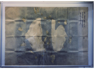
Picture Map of Matsushima: The circumference of the island is less than 3.9km. The distance from Oki Province to Matsushima is about 392km. Takeshima is about 118km from Matsushima.
(* See T1895000000103 for a clearer image of the writing.)
Content
Picture Map of Matsushima
| Related archives | T1895000000103 |
|---|
| Document title | Picture Map of Matsushima |
|---|---|
| Date created (Western calendar) | 〔middle of the 17th century〕 |
| Date created (Japanese era) | 〔Edo〕 |
| Author(s) / Editor(s) | |
| Publisher | |
| Name of publication | |
| Content | Picture map of Matsushima alone (present-day Takeshima). A photo taken when the picture map was exhibited in Yonago City in 1987. Supposed to have been owned by the Murakawa family, and it was presumably drawn around the mid-18th century. One of the most detailed picture maps of today's Takeshima, marked with information gained from first-hand observation of the shape of the islands, notation of channels, shores and others. |
| Language | Japanese |
|---|---|
| Public access | Open |
| Repository | Municipal Yonago Historical-museum (Japanese Only) |
| Medium | Photo |
| Copies | 1 page |
| Reference No. | T1600000000103 |
| Reference & Information | Follow the instruction at Municipal Yonago Historical-museum |
| Notes |


