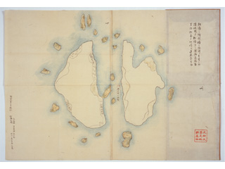
A picture map of Matsushima (present-day Takeshima). Its circumference is less than 3.9km/2.4miles. It is approximately 39km/24miles from Oki Province to Matsushima to cross the ocean, and it is approximately 118km/73miles from Matsushima to Takeshima (present-day Utsuryo Island (Ulleungdo)).
Content
Map of Matsushima
| Document title | Map of Matsushima |
|---|---|
| Date created (Western calendar) | 1895 |
| Date created (Japanese era) | Meiji 28 |
| Author(s) / Editor(s) | |
| Publisher | |
| Name of publication | |
| Content | A copy of a picture map of Matsushima (present-day Takeshima) drawn in the Edo period. Copied from a map owned by the Murakawa family of Yonago-cho (town). |
| Language | Japanese |
|---|---|
| Public access | Open |
| Repository | Historiographical Institute The University of Tokyo |
| Medium | Paper |
| Copies | 1 page |
| Reference No. | T1895000000103 |
| Reference & Information | Follow the instruction at Historiographical Institute The University of Tokyo |
| Notes |


