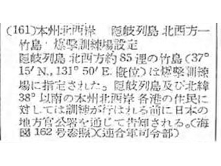
(161) Designation of Takeshima, on the northwestern coast of Honshu and northwest of the Oki Islands, as a bombing range.
Takeshima, located 85 nautical miles (157km) northwest of Oki-Rettō (Oki Islands) at approximately 37°15′North, 131°50′ East, was designated as a bombing range. The inhabitants of Oki-Rettō (Oki Islands) and the inhabitants of all the ports on the northwestern coast of Honshu, at latitude 38° or lower, will be notified prior to each use of this range. The notification will be disseminated to the general public through local Japanese offices. (See Nautical Chart No. 162) (Headquarters of the Allied Powers)
Content
Notification on Hydrographic No. 38
(Designation of Takeshima, on the northwestern coast of Honshu and northwest of the Oki Islands, as a bombing range)
| Related archives |
|---|
| Document title | Notification on Hydrographic No. 38 (Designation of Takeshima, on the northwestern coast of Honshu and northwest of the Oki Islands, as a bombing range) |
|---|---|
| Date created (Western calendar) | September 27, 1947 |
| Date created (Japanese era) | September 27, Showa 22 |
| Author(s) / Editor(s) | |
| Publisher | Ministry of Finance Printing Bureau |
| Name of publication | "Kampo" (official gazette) No. 6212 |
| Content | This material states that Takeshima was designated as a bombing range and that the general public would be notified before each use of the range. |


