Postcard Collection
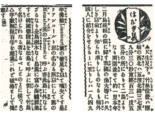
(text omitted)Takeshima is located 85 nautical miles (157 km) northwest of Oki at 37° 9' 30'' N, 131° 55' 0'' E. Takeshima consists of two islands, and the circumference is approximately 4km. It was incorporated into Shimane Prefecture in February of this year. Takeshima has been known to fishermen in our country for a long time, but Takeshima became known to foreigners when it was found by a French ship named the Liancourt in 1849. This is the reason Takeshima is called "Liancourt Rocks." However, "Liancourt Rocks," is the island in the name of "Memalai" in Russian, and "Hornet" in English as well. There are no trees on the island, there are many bird droppings, and sea lions gather there. While the Korean Utsuryo Island is called "Matsushima," "Liancourt Rocks" is named "Takeshima."(text omitted)
Content
Editorial from the Yomiuri Shimbun (newspaper) regarding the name Takeshima (July 1905)
| Related archives |
|---|
| Document title | Editorial from the Yomiuri Shimbun (newspaper) regarding the name Takeshima (July 1905) |
|---|---|
| Date created (Western calendar) | July 10, 1905 |
| Date created (Japanese era) | July 10, Meiji 38 |
| Author(s) / Editor(s) | |
| Publisher | Yomiuri Shimbunsha |
| Name of publication | Yomiuri Shimbun |
| Content | Takeshima was called "Matsushima" during the Edo Period and "Liancourt Island" in the early Meiji Period. This is an editor's reply to the question from a reader regarding the island being officially named "Takeshima" after its incorporation into Shimane Prefecture in 1905 (dated July 10, 1905). In the late 18th century, European explorers had differing measurements for the latitude and longitude of Utsuryo Island (Ulleungdo). This caused confusion over the name of the islands:"Matsushima" was used as the name for Takeshima starting in the Edo Period (17th century), but then it became the name for Utsuryo Island, and Takeshima became "Liancourt Rocks" and "Lyanko/Lanco Island" after a ship named "Liancourt" passed by Takeshima in 1849. Based on this background, this material shows that Utsuryo Island -- which was called Dagelet Island in the ROK -- should be called "Matsushima," and the island, which was called as "Liancourt Rocks" and known to Japanese fishermen for a long time, was officially named "Takeshima." Except for one typo (the Russian name "Memalai" should be spelled "Menelai"), this article shows the exact content of the Shimane Prefecture Notice No. 40 of February 1905, including the latitude and longitude measurements "37° 9' 30" N, 131° 55' 0" E." |


