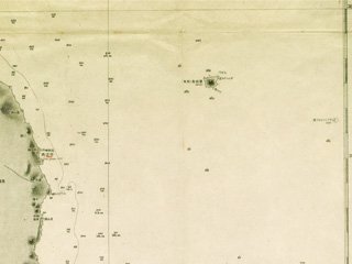
"Liancourt Rocks" (*present-day Takeshima)
Content
Nautical Chart No. 21 "CHŌSEN ZENGAN (COAST OF KOREA)"
| Document title | Nautical Chart No. 21 "CHŌSEN ZENGAN (COAST OF KOREA)" |
|---|---|
| Date created (Western calendar) | 1896 |
| Date created (Japanese era) | Meiji 29 |
| Author(s) / Editor(s) | Hydrographic Department (Hydrographic Office), Imperial Navy |
| Publisher | Hydrographic Department (Hydrographic Office), Imperial Navy |
| Name of publication | |
| Content | A nautical chart compiled by Capt. Kaneyuki KIMOTSUKI, Director-General of the Hydrographic Department. There is a description that this map was made on the basis of actual survey between 1874 and 1892, as well as recent surveys by the U.K. and Russia. It includes "Liancourt Rocks" (present-day Takeshima). |
| Language | Japanese |
|---|---|
| Public access | Open |
| Repository | The National Institute for Defense Studies |
| Medium | Paper |
| Copies | 4 pages |
| Reference No. | T1896000000101 |
| Reference & Information | Follow the instruction at The National Institute for Defense Studies |
| Notes |


