"Liancourt Rocks"
Content
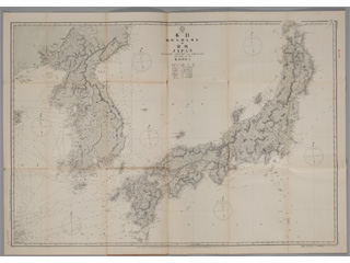
Nautical Chart No. 95 "JAPAN HONSHŪ KYUSHŪ AND SHIKOKU AND PART OF THE KOREA"
| Document title | Nautical Chart No. 95 "JAPAN HONSHŪ KYUSHŪ AND SHIKOKU AND PART OF THE KOREA" |
|---|---|
| Date created (Western calendar) | 1891 |
| Date created (Japanese era) | Meiji 24 |
| Author(s) / Editor(s) | Kaneyuki KIMOTSUKI |
| Publisher | Hydrographic Department, Imperial Navy |
| Name of publication | Naval Charts |
| Content | Nautical charts created based on the Ino map by Captain Kaneyuki KIMOTSUKI, Director-General of the Hydrographic Department. It includes Ulleungdo (Matsushima) and Liancourt Rocks (present-day Takeshima). "Liancourt Caves" in the 1st edition of 1878 has been corrected to "Liancourt Rocks". This proves that the positions of Takeshima and Ulleungdo were correctly marked. |
| Language | Japanese |
|---|---|
| Public access | Open |
| Repository | National Archives of Japan |
| Medium | Paper |
| Copies | 1 page |
| Reference No. | T1891000000101 |
| Reference & Information | Follow the instruction at National Archives of Japan |
| Notes |


