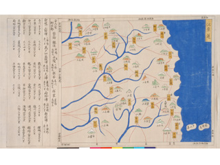
Uzan Island (Usando) is located west of Utsuryo Island (Ulleungdo).
Content
Map of Gangwon Province
| Document title | Map of Gangwon Province |
|---|---|
| Date created (Western calendar) | 1872 |
| Date created (Japanese era) | Meiji 5 |
| Author(s) / Editor(s) | |
| Publisher | |
| Name of publication | "Geographical Map of Chōsen (Joseon)" |
| Content | A general map of Chōsen (Joseon) formerly owned by the Geographic Bureau of the Ministry of Home Affairs. A picture map copied in 1872 from a picture map drawn by brush in Chōsen (Joseon) in 1592. Uzan Island (Usando) is drawn to the west of Utsuryo Island (Ulleungdo), revealing that this contradicts the South Korean claim that Uzan Island (Usando) is Takeshima. |
| Language | Japanese |
|---|---|
| Public access | Open |
| Repository | National Archives of Japan |
| Medium | Paper |
| Copies | 1 page |
| Reference No. | T1872000000203 |
| Reference & Information | Follow the instruction at National Archives of Japan |
| Notes |


