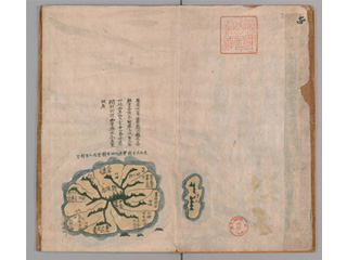
Usan
Content
| Document title | Daitoyochizu (Daedongyeojido) (The Great Map of the East Land) |
|---|---|
| Date created (Western calendar) | after 1861 |
| Date created (Japanese era) | after the first year of Bunkyuu |
| Author(s) / Editor(s) | Kim Jeong-ho |
| Publisher | |
| Name of publication | |
| Content | A map of the Korean peninsula made in the Kingdom of Chōsen (Joseon era). Orihon (accordion book), color map drawn with a brush. Unlike the woodblock printing book of 1861, Uzan Island (Usando) (which South Korea claims to be Takeshima) is depicted on the map of Utsuryo Island (Ulleungdo). However, judging from its location (the original "Seikyu-zu (Cheonggudo)" map by Kim Jeong-ho was a grid map) and shape, this Usando is not present-day Takeshima. |
| Language | Korean |
|---|---|
| Public access | Open |
| Repository | National Diet Library |
| Medium | Paper |
| Copies | 1 page |
| Reference No. | T1861000000103 |
| Reference & Information | Follow the instruction at National Diet Library. (Or, access the website of National Diet Library Digital Collections) |
| Notes | See "vol.14" to find the sample image of this material |


