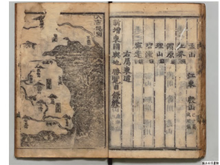
"Uzan Island (Usando)" is located west of Utsuryo Island (Ulleungdo)
Content
"Hachido-sozu (Map of the Eight Provinces of Korea (Paldo-chongdo)," "Tō-ran zu (Attached Map of the Survey of Geography of Korea)"
| Document title | "Hachido-sozu (Map of the Eight Provinces of Korea (Paldo-chongdo)," "Tō-ran zu (Attached Map of the Survey of Geography of Korea)" |
|---|---|
| Date created (Western calendar) | 1530 |
| Date created (Japanese era) | Kyouroku 3 |
| Author(s) / Editor(s) | No Sashin |
| Publisher | |
| Name of publication | Shinzo Togoku Yochi Shoran Jomoku (Sinjeung Dongguk Yeoji Seungram (The Revised and Augmented Edition of the Survey of the Geography of Korea)) - Introduction |
| Content | A map attached to Shinzo Togoku Yochi Shoran (Sinjeung Dongguk Yeoji Seungram (The Revised and Augmented Edition of the Survey of the Geography of Korea)), an official topography compiled in the Kingdom of Chōsen (Joseon) era (1392-1897). "Uzan Island (Usando)", claimed by South Korea as present-day Takeshima, appears to the west of Utsuryo Island (Ulleungdo), closer to the Korean Peninsula and described as comparable size of Utsuryo Island (Ulleungdo). |
| Language | Korean |
|---|---|
| Public access | Open |
| Repository | National Archives of Japan |
| Medium | Paper |
| Copies | 2 pages |
| Reference No. | T1530000000101 |
| Reference & Information | Follow the instruction at National Archives of Japan (Or, access the National Archives Digital Archives Website) |
| Notes | Sample of this image is a copy of the picture of the digital archives |


