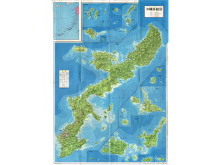
Map of Okinawa Prefecture, Senkaku Islands (Uotsuri, Kita-kojima, Minami-kojima, Kuba, Taishō, Tobise, Oki-no-kitaiwa, and Oki-no-minamiiwa Islands)
Content
Comprehensive map of Okinawa Prefecture
| Related archives |
|---|
| Document title | Comprehensive map of Okinawa Prefecture |
|---|---|
| Date created (Western calendar) | May 15, 1972 |
| Date created (Japanese era) | May 15, Showa 47 |
| Author(s) / Editor(s) | |
| Publisher | Buyodo Co., Ltd |
| Name of publication | Documents Related to Okinawa Reversion Ceremony |
| Content | This map is one of the collection materials owned by the late Edward Freimuth, Director of the Liaison Department of the United States Civil Administration of the Ryukyu Islands (USCAR). (It was donated to the Okinawa Prefectural Archives.) This map shows the islands of Okinawa returned from the United States on May 15, 1972. The area of the Senkaku Islands includes Uotsuri, Kita-kojima, Minami-kojima, Kuba, Taishō, Tobise, Oki-no-kitaiwa and Oki-no-minamiiwa Islands. |


