| Document title |
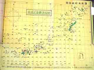
Fisheries Promotion Support Projects FY1967 Fishery Resource Survey (Map of bonito fishing grounds in Ryukyu coastal waters) |
| Date created (Western calendar) |
June 1967 |
| Date created (Japanese era) |
June Showa 42 |
| Author(s) / Editor(s) |
Production Section, Agricultural Department, Government of the Ryukyu Islands / Fisheries Section, Government of the Ryukyu Islands |
| Publisher |
|
| Name of publication |
Fisheries Promotion Support Projects FY1967 Fishery Resource Survey |
| Content |
This "Map of bonito fishing grounds in Ryukyu coastal waters" was compiled by the Fisheries Section of the Government of the Ryukyu Islands. Bonito fishing grounds in seas around the Senkaku Islands are marked with " ●, " and fishing zones near the Islands are numbered 42, 60, 61, 62 and 65. |