Summarized Report on the Joint Survey of Ryukyu Coastal Waters
The 2nd Survey (Ocean observation and demersal fish pole-and-line trial)
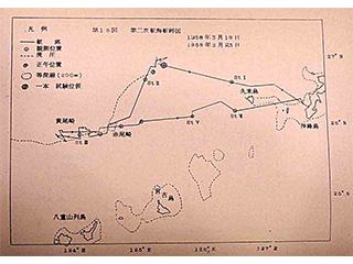
The 2nd navigation route map March 19th-23rd, 1958 [Surveys on the area between Sekibisho and Kobisho 3/20-3/21] [See PDF]
Content
Ryukyu Fisheries Research Institute / Operations Report / FY1958
| Document title | Ryukyu Fisheries Research Institute / Operations Report / FY1958 |
|---|---|
| Date created (Western calendar) | [1959] |
| Date created (Japanese era) | Showa 34 |
| Author(s) / Editor(s) | Ryukyu Fisheries Research Institute |
| Publisher | Ryukyu Fisheries Research Institute |
| Name of publication | Operations Report [FY1958] |
| Content | A joint survey report on ocearn observation by the Ryukyu Fisheries Research Institute and Fisheries Agency of Japan. They conducted a fishing ground survey on longline fishing of tuna around Ryukyu Islands (the 1st survey) and a survey on demersal fish pole-and-line trial on the continental shelves at the west of Okinawa in East China Sea (the 2nd survey) by Shunyo-Maru, a research vessel of Fisheries Agency of Japan. At the 2nd survey, they navigated in the sea around Taisho and Kuba Islands in the Senkaku Islands and conducted an ocean observation. |
| Language | Japanese |
|---|---|
| Public access | Open |
| Repository | Okinawa Prefectural Archives |
| Medium | Paper/Booklet |
| Copies | 22 |
| Reference No. | S1959000000103 |
| Reference & information | Follow the instruction at the Okinawa Prefectural Archives |
| Notes |

