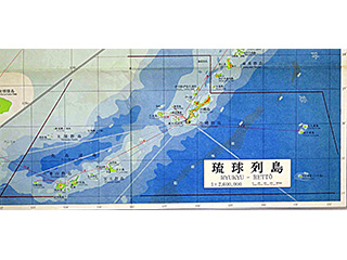
Complete map of Ryukyu (2)
Yaeyama Gunto>The Senkaku Islands>Uotsuri Island, Kitakojima Island, Minamikojima Island, Tobise Island, Okinokitaiwa Island, Okinominamiiwa Island, Kobi-Shō (Kuba Island), Sekibi-Shō (Taisho Island)
Content
A Complete Map of Ryukyu
| Document title | A Complete Map of Ryukyu |
|---|---|
| Date created (Western calendar) | April, 1958 |
| Date created (Japanese era) | April, Showa 33 |
| Author(s) / Editor(s) | Ed. Kosei AKAMINE |
| Publisher | Ryukyu Bunkyo Tosho |
| Name of publication | |
| Content | One sheet of complete map of Ryukyu Islands (Okinawa Prefecture). Okinawa main Island and the surrounding islands are drawn in the front page, and Sakishima Islands (Miyako Islands, Yaeyama Islands) are drawn in the back page. The Senkaku Islands are included in the part of Yaeyama Islands. From Kagoshima Prefecture in the south of Kyushu, to Tokara Islands, Amami Islands, Ryukyu Islands, and northern part of Taiwan are also drawn. The geographical border of Ryukyu Islands including the Senkaku Islands is outlined by red line. A map with a scale of 1:150,000. |
| Language | Japanese |
|---|---|
| Public access | Open |
| Repository | Okinawa Prefectural Library (Japanese Only) |
| Medium | Paper/Map |
| Copies | 10 |
| Reference No. | S1958040000103 |
| Reference & information | Follow the instruction at the Okinawa Prefectural Library |
| Notes |

