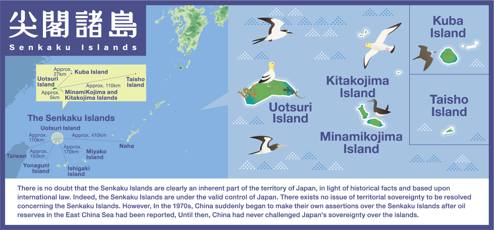
Senkaku Islands
Using videos, panels, exhibits, etc., visitors can learn basic information on the geography, history, and current situation of Senkaku Islands.
Videos
Basics
The Senkaku Islands
Japan has incorporated the Senkaku Islands into its territory through lawful means under the international legal framework which existed at that time, and maintained valid control over them.
Until the second half of the 19th century, the Senkaku Islands were uninhabited islands
around the Ryukyu Islands that did not belong to any country.
Recognizing that the feathers of albatrosses and the shells of great green turban were found to sell well
overseas, from around 1889, Japanese fishermen began to move into the Senkaku Islands. In order to manage
the fishermen, the Japanese Government carefully confirmed that the Senkaku Islands were not only
uninhabited, but also not under the control of any country, including Qing, and then incorporated them
into Okinawa Prefecture by a Cabinet decision on January 14, 1895. This action is in accordance with the
practice of acquiring territorial rights under international law.
In 1896, private businessman Koga Tatsushiro began full-scale development of the islands with the
permission of the Government. Many Japanese people settled on the Senkaku Islands, engaging in activities
such as the production of bonito flakes and the collection of feathers. At the height of the period around
1908, as many as 99 households, with a total of 248 Japanese people, lived on the Senkaku Islands. In
addition, the Government has maintained open and valid control over the islands through measures such as
land surveys and business permits.
After WWII, the Senkaku Islands were not included in the territories Japan renounced under the San
Francisco Peace Treaty, which entered into force in 1952, and were placed under US administration as part
of “Nansei Shoto(Islands) south of 29°north latitude”(Article 3 of San Francisco Peace Treaty). The fact
that the Senkaku Islands were part of areas placed under US administration was clearly stipulated in a
proclamation issued by the United States Civil Administration of the Ryukyu Islands (USCAR). However,
there were no protests from China at all.
Later, under the Agreement between Japan and the United States of America concerning the Ryukyu Islands
and the Daito Islands, administrative rights over Okinawa including the Senkaku Islands were returned to
Japan.
Documents concerning the Yaeyama Islands – Kuba Island
According to this document, a total of 78 people went to Kuba and Uotsuri Islands, which indicates that there were already many fishermen operating around the islands by that time.
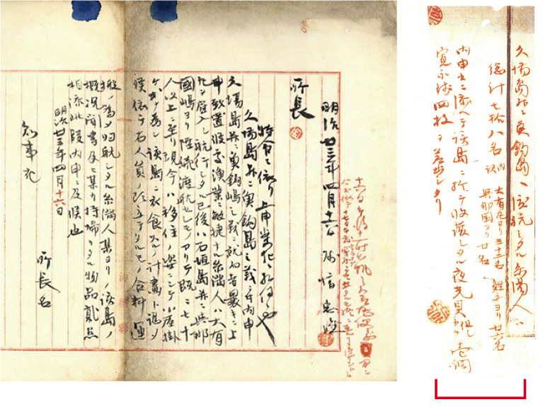
Excerpt (Provisional Translation)
A total of 78 Itoman fishermen went to the islands of Kuba and Uotsuri. They consisted of 32 persons traveling on the Daiyu Maru, 26 on bonito ships, and 20 from Yonaguni Island. The report was accompanied by one yakogai (green turban snail) shell harvested on said islands, for which I disbursed four Kan'ei coins. [Hanawa's personal seal]
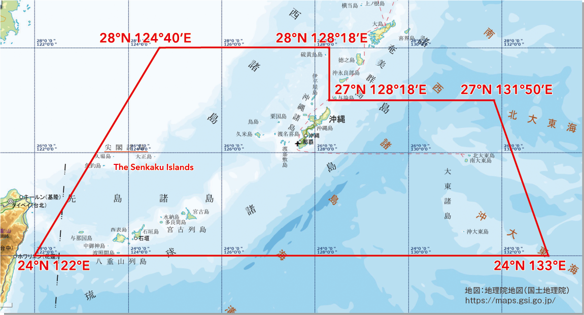
The limit of the area of the Ryukyu Islands shown by USCAR’s proclamation etc.

(Provisions of the Government of the Ryukyu Islands) (February 29, 1952)
② Area of the Ryukyu Islands shown by Civil Administration Proclamation No. 27
(Geographic Boundary of the Ryukyu Islands) (December 25, 1953)
*USCAR…United States Civil Administration of the Ryukyu Islands
China and Taiwan began making their own assertions about the Senkaku Islands only after a UN agency report had indicated the existence of potential oil reserves in the East China Sea.
In 1969, the Economic Commission for Asia and the Far East (ECAFE), the United Nations, published a
report stating that waters around the Senkaku Islands "may be one of the most prolific oil reserves in the
world."
It was only after the publication of this report that China and Taiwan, both of which had never claimed
territorial sovereignty over the Senkaku Islands, began making their own assertions about the Islands.
They are making claims over the islands without valid grounds under international law, and they cannot
change the fact that they had never claimed sovereignty at any point in history until the early 1970s.
In recent years, activities by China Coast Guard vessels have been identified almost every day in Japan’s
contiguous zone around the Senkaku Islands, and intrusions into Japan’s territorial sea have also been
occurring. In response to such unilateral attempts by China to change the status quo by force, Japan has
repeatedly lodged strong protests and requested the withdrawal of Chinese vessels. With the determination
to defend Japan’s territory as well as territorial sea and airspace, the Japanese Government will continue
to take a calm and resolute approach to the situation in close coordination with relevant organizations.
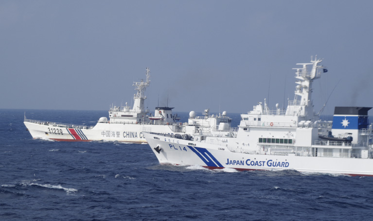
Photo: Japan Coast Guard
The Senkaku Islands have been Japanese territory since 1895, and no country had
expressed objection to Japan's territorial sovereignty over the islands.
However, in the early 1970s, when it was discovered that there were oil reserves in the sea around the
Senkaku Islands, China and Taiwan began to claim that the Senkaku Islands belonged to them. China has
sent ships to the waters around the Senkaku Islands in a unilateral attempt to change the status quo by
force.

For those who want to know more
The Senkaku Islands in pre-modern period
Senkaku Islands in pre-modern period
– uninhabited islands ruled by no country –
Until they were incorporated into Okinawa Prefecture in 1895, the Senkaku Islands were uninhabited
islands that belonged to no country. The Senkaku Islands were used as navigational markers for ships
traveling in the East China Sea, and they were known from ancient times, appearing in documents and maps
of the Ryukyu Kingdom (Figure 1). In addition, the Senkaku Islands are also depicted in the sailing
route charts (generally referred to as “Asian sailing route charts”) of many of the 17th century Red
Seal ships (Figure 2).
From the end of the 18th century, as Western ships began to explore and survey the waters around the
Japanese archipelago, the Senkaku Islands were also sighted and surveyed by these ships (Figure 3).
The Senkaku Islands are also mentioned in records of Chinese envoys to Ryukyu, and China has used this
as a basis for its claim to sovereignty over the Senkaku Islands, but this is not a valid argument.
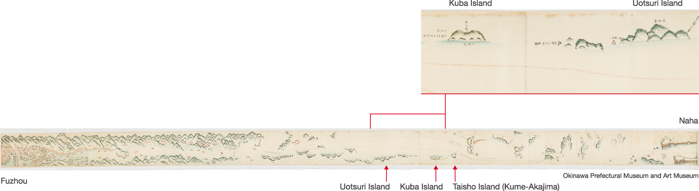
(Figure 1) Tobin Kokaizu [a scroll that depicts a navigation route between Naha Port in the Ryukyu Dynasty and Fuzhou Port in China] in the collection of Okinawa Prefectural Museum and Art Museum
A scroll (date unknown) depicting a navigational route between the port of Naha in the Ryukyu Kingdom
and the port of Fuzhou in China.
It can be seen that the ships that sailed from Fuzhou Port passed through Uotsuri Island, Kuba Island,
Kume-Akajima (Taisho Island), and Kume Island before returning to Naha Port. The Senkaku Islands also
appear in Chinese records such as the records of the Ming and Qing Dynasty envoys (冊封使録: Sakuho
Shiryoku), but there is no record that mentions or depicts the five islands (the same number as the
actual number) between Uotsuri-jima and Kuba-jima described in this scroll.
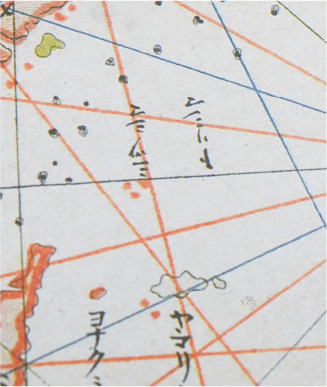
(Figure 2) “Leather-bound nautical chart (nautical chart of Asia)” in the collection of the Jingu Chokokan Museum
Shu-in-sen (Red Seal ships) were trading ships that were granted “shu-in-jo” (licenses bearing the
Shogun's red seal) by the Edo Shogunate in the first half of the 17th century, and they made large
profits from trading with various places in Southeast Asia. This map of voyages to Asia was owned by
Kadoya Shichirobei, who was engaged in shu-in-sen trading, and after his death, it was sent back to
Japan as one of his belongings. This is the only map of the shu-in-sen voyages with a clear history, and
it has pinholes showing it was actually used.
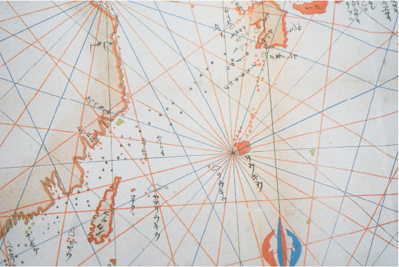
The Senkaku Islands are shown on this map as “Torishima” (islands of birds) and “Mitsushima” (three
Islands), and it is thought that this is how the islands were called at the time. There are also many
other maps of the shu-in-sen voyages from the same period that depict islands in the actual location of
the Senkaku Islands.
(Figure 3) La Perouse: “Part of the Island of Quelpaert, Hoapinsu, Dagelet, Botol & Kumi."
From the end of the 18th century, as Western ships began to explore and survey the waters around
the Japanese archipelago, the Senkaku Islands were also sighted and surveyed by these ships.
French explorer La Perouse observed the islands of the Senkaku Islands during his voyage in 1787,
and recorded them on his nautical chart as Hoapinsu (Uotsuri Island) and Tyaoyusu (Kuba Island),
indicating their location by latitude and longitude. The names and locations he recorded were
adopted by Western nautical charts and sailing directions, and in Japan, the Japanese translation of
Hoapinsu, “Wahei-san” (和平山), became the alternative name for Uotsuri Island.
In 1845, Captain Belcher of the British warship Samarang, which visited Ryukyu, saw Minamikojima and
Kitakojima Islands and named them the Pinnacle Islands because of their pointed rocky peaks. This is
the origin of the name Senkaku Islands.
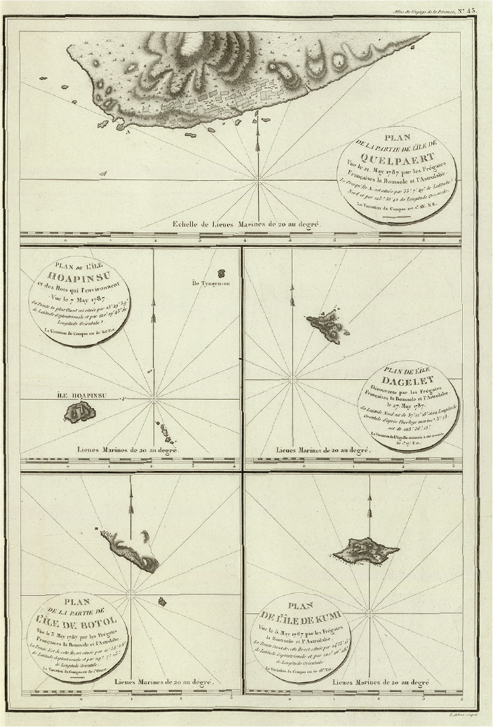
David Rumsey Map Center, Stanford Libraries
The Senkaku Islands have been known to sailors from many countries for a long time. They were uninhabited islands that did not belong to any country. People only observed them during their voyage.
The Senkaku Islands in 1885-1895
1885-1895: Landing surveys of the Senkaku Islands, expansion of fishing operations and incorporation into the Japanese territory
1. The Port Hamilton Incident and the landing survey of the Senkaku Islands (1885)
In the second half of the 19th century, Western countries began to advance into Asia in earnest, and the struggle for power between Britain and Russia intensified in East Asia. In this context, in 1885 (Meiji 18), Britain occupied Korea's islands of Port Hamilton, which had a good harbor and was a strategic stronghold, as a base against Russia. The Japanese Government was concerned that European countries might also occupy the outlying islands around Japan. For this reason, the Japanese Government worked to strengthen surveillance of the surrounding remote islands, such as the Sakishima Islands and the Goto Islands, and as part of this, they dispatched Ishizawa Hyogo, an official from Okinawa Prefecture, and other officials to the uninhabited islands of the Daito Islands, as well as the Senkaku Islands, which were not yet under government control, to conduct a landing survey.

2. The Advance of Fishermen to the Senkaku Islands and the Incorporation of the Islands into Japanese Territory (1889-1895)
The Senkaku Islands were surveyed due to the need to strengthen surveillance of outlying islands, but from around 1889, fishermen began to move to the islands after learning that products from the islands, such as shells of great green turbans and albatross feathers, were well sold in Europe and America. For this reason, Okinawa Prefecture submitted several proposals to the central government to incorporate the Senkaku Islands into Okinawa Prefecture in order to manage the activities of these fishermen. At the same time, the Prefecture also sought to provisionally manage the islands. The Senkaku Islands were incorporated into Okinawa Prefecture in 1895 after the Government carefully ascertained that they were not under the control of any country, including the Qing.
Events and Incidents between 1885-1895
| 1885: | Okinawa Prefectural officials landed on the Senkaku Islands to conduct a survey. The construction of national markers was postponed. |
|---|---|
| 1889: | The Yaeyama Island Joint Fisheries Company, an organization to promote the fishing industry, was established on Ishigakijima Island. |
| 1890: | A survey by the Okinawa Prefectural Government of the fishing situation on the Senkaku Islands revealed that a total of 78 Okinawan fishermen had traveled to the Senkaku Islands (Figure 4). |
| 1890: | The Governor of Okinawa Prefecture proposed that the central government incorporate the Senkaku Islands under the jurisdiction of the Yaeyama Island Office “because it is necessary to control the activities of fishermen.” |
| 1891: | The Governor of Okinawa Prefecture issued an order to provisionally put the Senkaku Islands under the jurisdiction of Yaeyama Island Police Station (Figure 5). |
| 1893: | The Governor of Okinawa Prefecture again proposed that the Senkaku Islands be incorporated into Okinawa Prefecture, saying that it is necessary to control the fishing activities of fishermen in the area (Figure 6). |
| 1895: | In response to the proposal from Okinawa Prefecture, the Japanese Government incorporated the Senkaku Islands into the jurisdiction of Okinawa Prefecture for the need to control fishermen (Figure 7). |
Figure 4 Documents concerning the Yaeyama Islands-Kuba Island
In this document, a total of 78 people went to Kuba and Uotsuri Islands, which indicates that there were already many fishermen operating around the islands by that time.
Excerpt from the document
A total of 78 Itoman residents
went to the islands of Kuba and Uotsuri.
They consisted of 32 persons traveling on the Daiyu Maru, 26 on bonito ships, and 20 from
Yonaguni.
The report was accompanied by one yakogai (green turban snail) shell harvested on said islands,
for which I disbursed four Kan'ei coins. [Hanawa's personal seal]
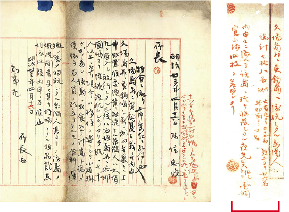
Figure 5 Okinawa Prefectural Police Statistics (1891)
This report records that the Governor of Okinawa Prefecture issued an order to the Police in December 1891 that the Akon-kuba Islands (i.e., the Senkaku Islands) be provisionally placed under the jurisdiction of Yaeyama Islands Police Station.
Excerpt from the document
(1891) On the same day and same month (December 11) Prefectural instruction No. 47 states that the Akon-kuba Islands are provisionally placed under the jurisdiction of the Yaeyama Islands Police Station.
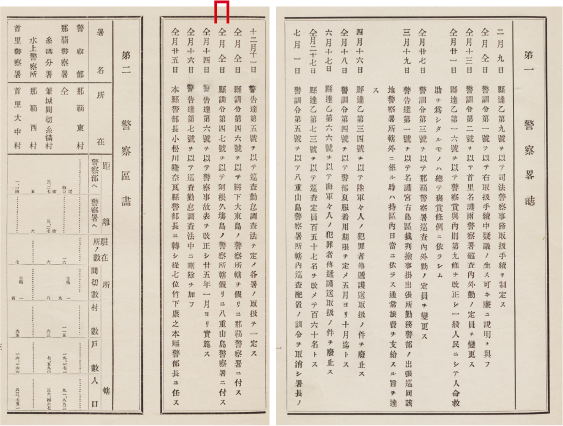
Figure 6 Proposal for incorporating the islands into Okinawa Prefecture and erecting national markers
Excerpt from the document
Recently, people are coming to the islands to attempt fishery and other activities, and because these not infrequently involve legal control, I [Governor of Okinawa Prefecture] would like to erect markers of this Prefecture's jurisdiction, as I reported in detail back in 1885. I therefore urgently request your guidance, and hereby once again make a proposal to that effect, enclosing copies of my previous proposal and your instruction.
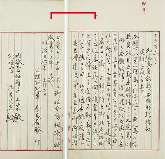
(Miscellaneous Matters Related to Imperial Territory) November 2, 1893 (Meiji 26)
Repository: Diplomatic Archives of the Ministry of Foreign Affairs of Japan
Figure 7 Cabinet decision permitting Okinawa Prefecture to erect national markers and have jurisdiction over the Senkaku Islands
This document contains the text of the Cabinet decision permitting Okinawa Prefecture to have jurisdiction over Uotsuri and Kuba Islands (dated January 14, 1895) and the text of a draft instruction to the prefecture.
Excerpt from the document
We [the members of the Cabinet] have no particular objection regarding the matter of permitting the erection of markers as requested by the Governor of Okinawa Prefecture by permitting the Prefecture to have jurisdiction over the islands.
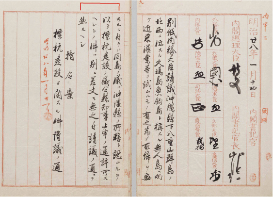
Repository: National Archives of Japan
Japanese fishermen began to move into the Senkaku Islands from around 1889. Albatross feathers were used for futons, great green turban shells were used for buttons, and bird specimens and stuffed birds were also exported overseas. The Senkaku Islands were incorporated into Japanese territory in 1895 in order to manage the activities of these fishermen.

The Senkaku Islands under the US Administration
After WWII: Okinawa including the Senkaku Islands was Placed under US Administration
With the entry into force of the San Francisco Peace Treaty in 1952, the Ryukyu Islands were officially
placed under US administration as the “Nansei Shoto (Islands) south of 29 degrees north latitude.” The
US Civil Administration of the Ryukyu Islands (USCAR), which was established in December 1950 (see Fig.
8), clearly stipulated the range of the Ryukyu Islands under its administration by latitude and
longitude in such documents as Civil Administration Ordinance No. 68 (Fig. 9) and Civil Administration
Proclamation No. 27 (Fig. 10), and the Senkaku Islands have consistently been included within that
range. The Senkaku Islands had been openly administered by the United States as part of the Ryukyu
Islands.
To begin with, the United States recognized the Senkaku Islands as part of Okinawa even before the San
Francisco Peace Treaty entered into force. For example, in January 1948, the U.S. military designated
Kuba Island as a permanent danger zone for bombing practice. The US military not only notified Okinawan
fishing-related organizations when it designated Kuba Island as a bombing range, but also when it used
it for training (Fig. 11), and Kuba Island was openly used by the US military, but there is no evidence
that China or Taiwan raised any objections at the time. Taisho Island was also designated as a bombing
range in 1956.
In 1971, the Agreement between Japam and the United States of America concerning the Ryukyu Islands and
the Daito Islands was signed between Japan and the United States, and administration over Okinawa was
returned to Japan. The Agreed Minutes of the agreement provided that the geographic scope of the return
was the area specified by USCAR Proclamation No. 27 (December 25, 1953), which included the Senkaku
Islands.
Figure 8 Chart: Governance system under administration by the US

Figure 9 USCAR Ordinance No. 68 (Provisions of the Government of the Ryukyu Islands)
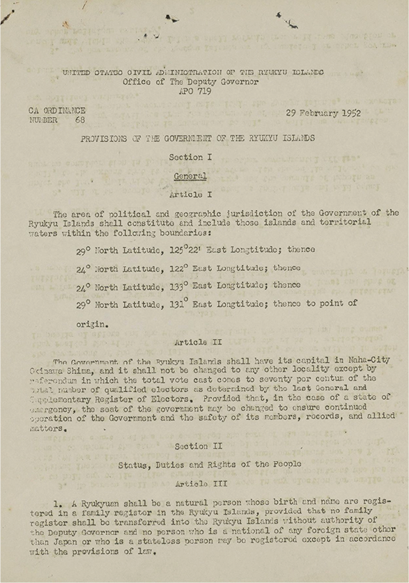
February 29, 1952 (Showa 27)
Repository: Okinawa Prefectural Archives
Figure 10 USCAR Proclamation No. 27 (Geographical limit of the Ryukyu Islands)
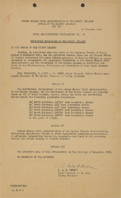
December 25, 1953 (Showa 28)
[Repository] Okinawa Prefectural Archives
Figure 11 Oki Sui No. 44 (Concerning no-fishing zones due to bombing practice)
This document is a notice dated April 22, 1948 (Showa 23) from the Okinawa Civilian Administration to
the Chairman of the Okinawa Fisheries Association and other fishery-related personnel regarding the
fishing ban zones ordered by the US Military Government in conjunction with the implementation of
bombing practice by the US military.
The areas designated as no-fishing zones were those that the US military had designated as permanent
danger zones for their bombing and live-fire training grounds, including (A) the area around Kobisho
(Kuba Island) within a 5-mile radius.
Despite such notifications, there is no evidence that China or Taiwan raised any objections at the time.
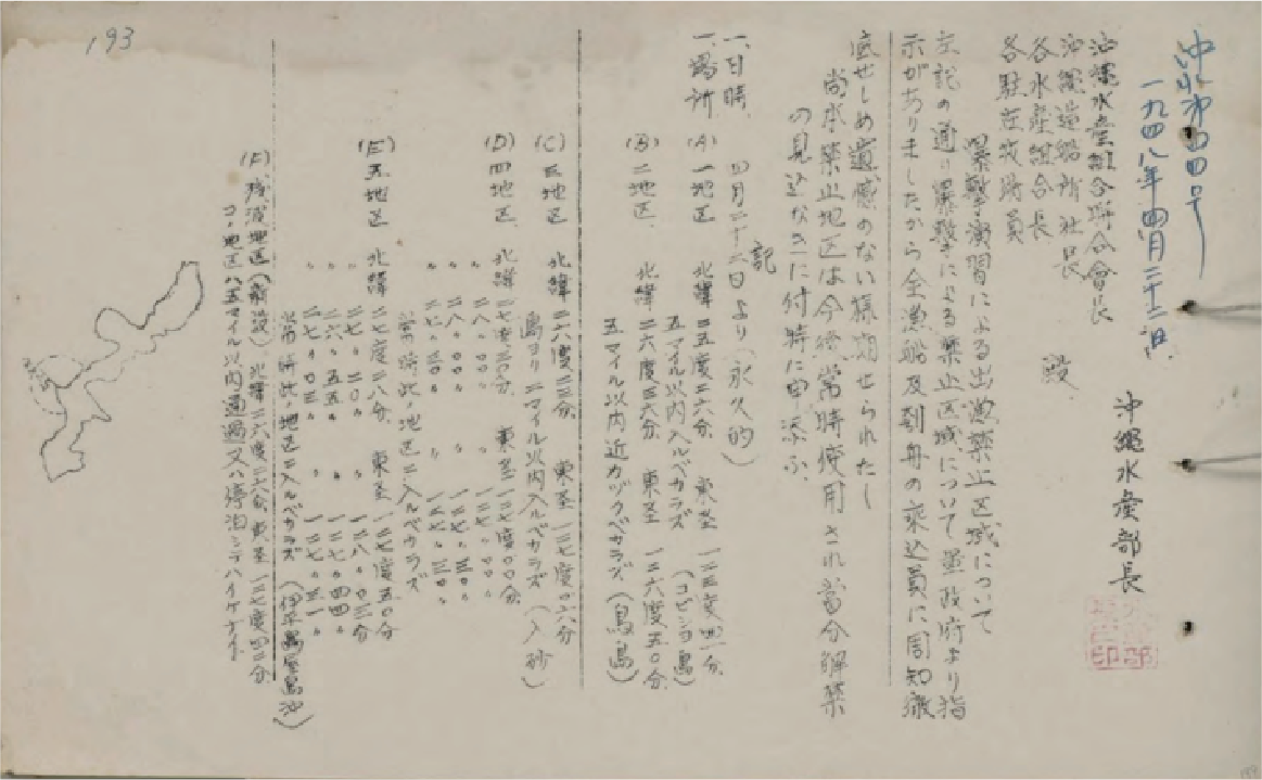
Figure: The limit of the area of the Ryukyu Islands shown by USCAR’s proclamation etc.
(Provisions of the Government of the Ryukyu Islands) (February 29, 1952)
② Area of the Ryukyu Islands shown by Civil Administration Proclamation No. 27
(Geographic Boundary of the Ryukyu Islands) (December 25, 1953)
Figure 12 The area of return under the Okinawa Reversion Agreement
After WWII, the US openly administered the Senkaku Islands as part of the Nansei Islands, but neither China nor Taiwan expressed objection! This means that neither China nor Taiwan considered the Senkaku Islands as part of Taiwan.

The Senkaku Islands in Chinese official maps
China altered its maps after 1971
In the 1960 edition of the “World Atlas” published by the China Map Publishing House (a publishing
house directly under the State Bureau of Surveying and Mapping of China), the Senkaku Islands were
included on the map of Japan, but in the 1972 edition of the same atlas, they were removed from the map
of Japan.
In addition, in the 1972 edition, the name “Diaoyu Island” was added to the map of China.
Figure 13 1960 edition
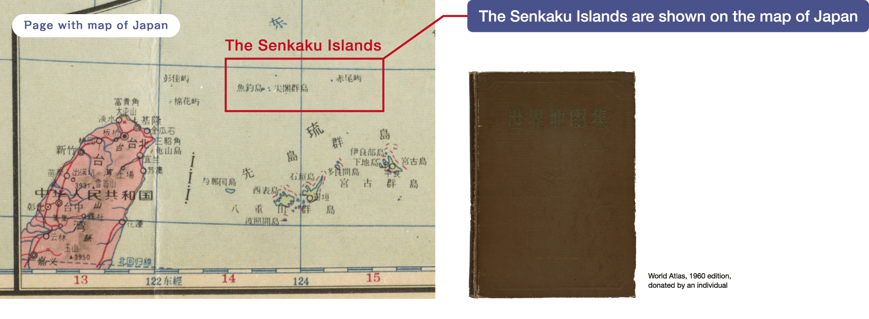
Figure 14 1972 edition
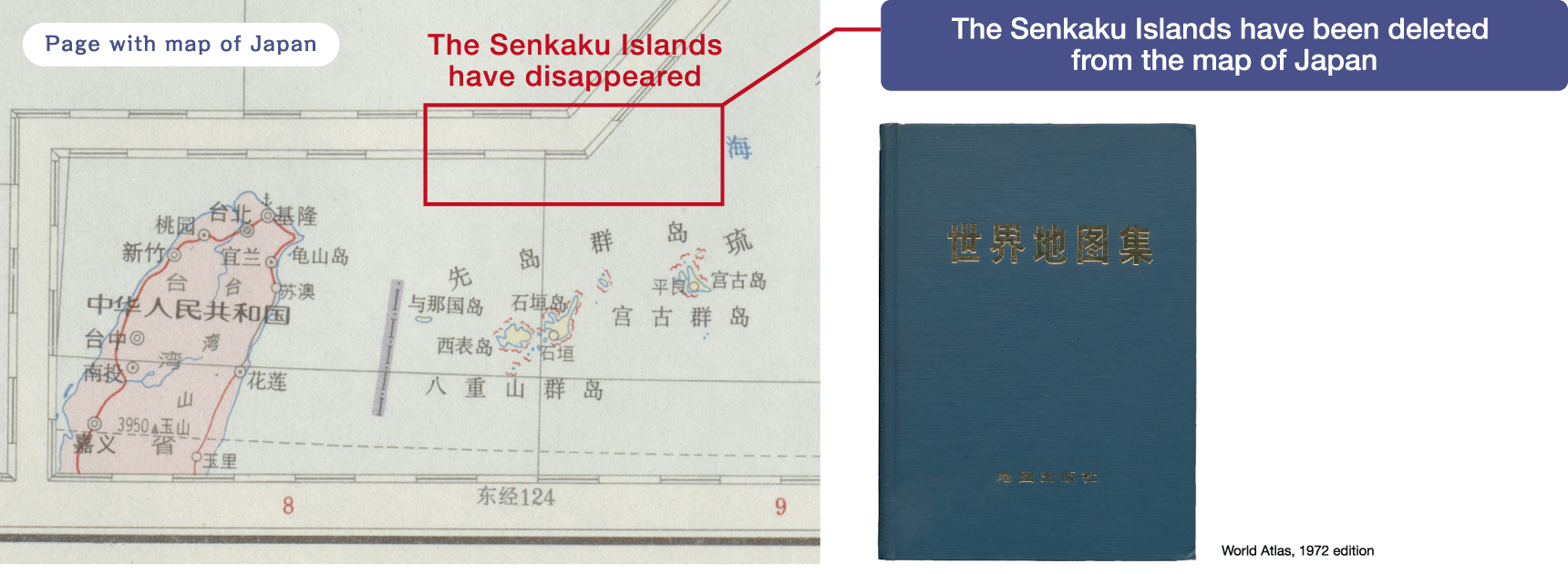
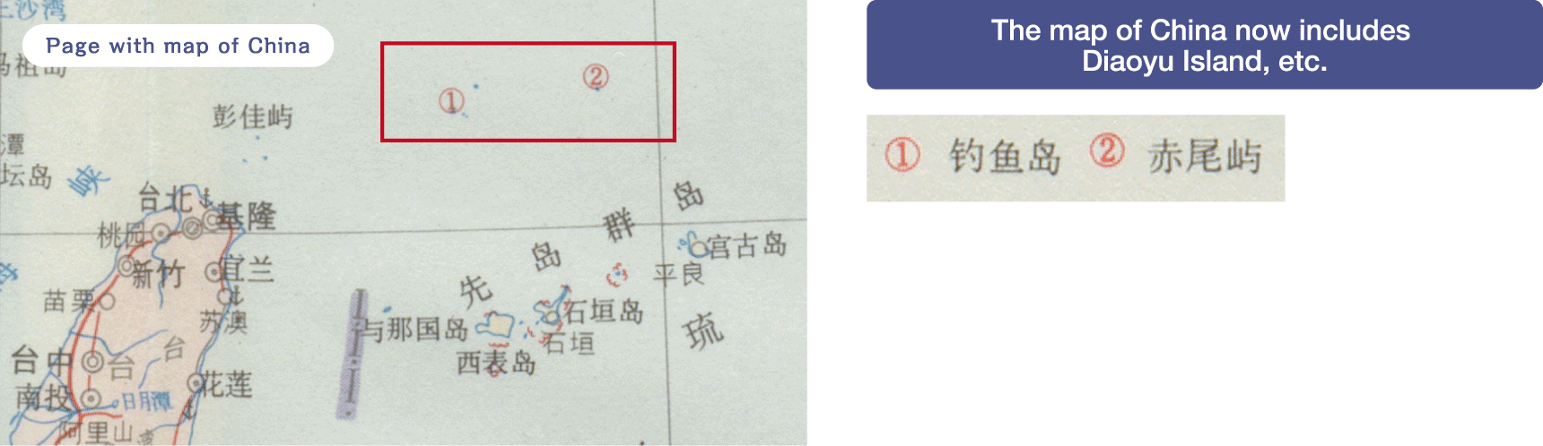
China changed its map after 1971!
Exhibit
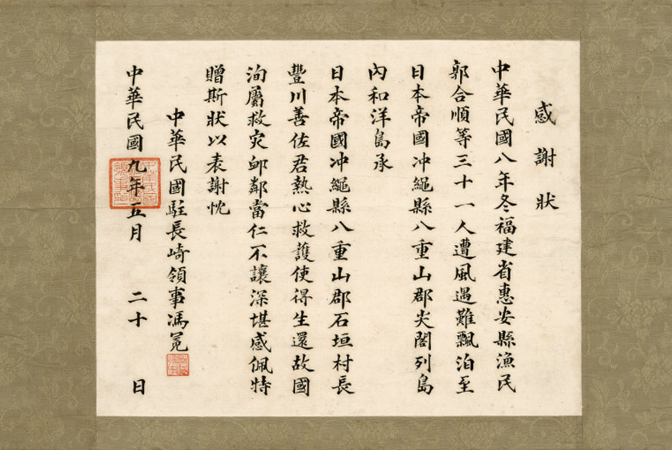
Letter of appreciation to Toyokawa Zensa for rescuing Senkaku Islands Shipwreck
In the winter of the 8th year (1919) of the Republic of China, 31 fishermen, including Guo Heshun from Hui'an County, Fujian Province, were lost due to stormy winds and were washed ashore on the Wayo Island (sic; Wahei Island. another name of Uotsuri island) of the Senkaku Islands, Yaeyama District, Okinawa Prefecture, Empire of Japan. Thanks to the enthusiastic rescue work by Village Mayor Toyokawa Zensa of Ishigaki Village, Yaeyama District, Empire of Japan, they were able to safely return to their homeland. With a deep respect and admiration toward the people of the village who were willing and generous in the rescue operation, I express my gratitude by this letter.