Incorporation Takeshima into Shimane Prefecture in Meiji Era
Opening the country – Development into a modern nation under the Meiji Government
In the late 19th century, with advances by European and American nations into Asia, international relations in the region became complex. The Meiji Government faced the critical challenges of modernizing the nation as well as consolidating the local governing system, and clarifying the status of peripheral islands.
In 1880 the Meiji Government dispatched the warship Amagi for a field study. From around this time until the early 20th century, activities in the private sector have been gradually intensified surrounding Takeshima, which required the government to take measures to prohibit travel to Utsuryo Island.
Temporary confusion of names and locations of Utsuryo Island and Takeshima
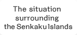
Present-day Takeshima used to be called Matsushima Chart 1
Present-day Takeshima was once called “Matsushima” in Japan, whereas Utsuryo Island was called “Takeshima” or “Isotakeshima.”
From the late 18th to 19th century, the geographic recognition was confused and an imaginary island appeared on maps Chart 2
In 1787, the French explorer Jean-Francois de Galaup, Conte de La Pérouse, named Utsuryo island “Dagelet.” The British explorer James Colnett also named it “Argonaut” in 1789. However, as there was some inaccuracy in the latitudinal and longitudinal charting, Utsuryo Island ended up being depicted as consisting of two separate islands on the maps subsequently produced in Europe.
A doctor named Philipp Franz von Siebold created a “Map of Japan” (1840) in Europe. He had learned from various Japanese documents and maps that two groups of islands, which were, from west to east, “Takeshima” (present-day Utsuryo Island) and “Matsushima” (present-day Takeshima), were located between the Oki Islands and the Korean Peninsula. Siebold listed an imaginary island between the Korean Peninsula and Utsuryo Island as “Takashima” and Utsuryo Island as “Matsushima” on his map. (Chart 2) This caused further confusion by giving a different name, “Matsushima,” to Utsuryo Island, which had consistently been called “Takeshima” or “Isotakeshima” until then.
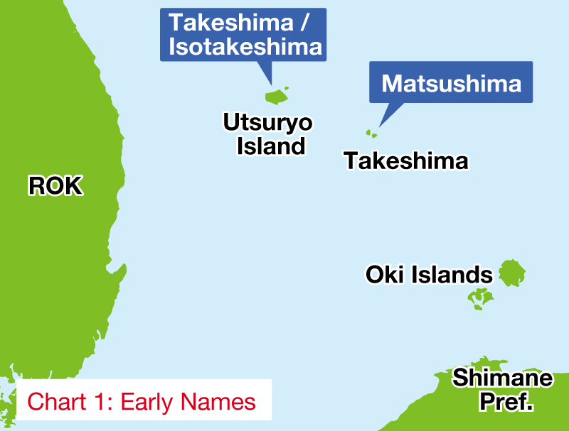
Chart 1: Early Names
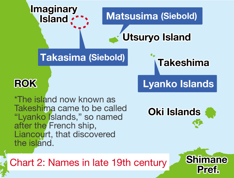
Chart 2: Names in late 19th century
The 1880 field study clarified the situation Chart 3
Receiving requests to develop “Matsushima,” the Government conducted a field study in 1880 in order to clarify the relationship among the different names of the islands, and confirmed that the island referred to as “Matsushima” in the request was actually “Utsuryo Island.” Therefore, Utsuryo Island came to be called “Matsushima,” which raised the question of what to call the island now known as “Takeshima.” To resolve this issue, the Japanese Government changed the traditional names, officially naming present-day Takeshima as such in 1905.
Chart 3 Map of Japan (Siebold)
1840 (Tenpou 11)
[Repository] National Museum of Japanese History
January 28, 1905 (Meiji 38)
Requested for lease by Japanese citizen, the Japanese Government incorporated Takeshima into Shimane Prefecture by Cabinet decision. No.6-7
Around 1900, the sea lion hunting became active around Takeshima and soon excessive competition became a concern. Yozaburo Nakai, a resident of the Oki Islands in Shimane Prefecture, submitted a request in September 1904 to three government ministers (the Home Minister, the Foreign Minister, and the Agriculture and Commerce Minister) for leasing “Lyanko Islands.”
Upon the request from Nakai and after hearing the opinion of Shimane Prefecture, the government stipulated on January 28, 1905, through a Cabinet decision, that the islands would be officially named “Takeshima,” and that the islands would come under the jurisdiction of the Oki Islands branch office of the Shimane Prefectural Government.
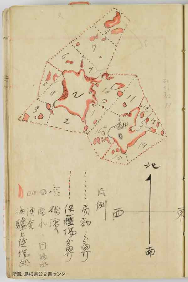
Attached map in the request for incorporation into the territory and lease of "Lyanko Islands” (copy)
This page with a map was contained in the request that Yozaburo Nakai submitted to the Government for leasing Takeshima in 1904. Nakai pointed out that the number of fishermen hunting sea lions was increasing, while a decline in the number of sea lions in the area was being observed and explained that the purpose of the requested lease was to avert competition and introduce catch limits, among other reasons. The map indicates sea lion landing areas.
Yozaburo Nakai 1904 (Meiji 37)
[Repository] Shimane Prefecture Public Records Center
Cabinet Decision of January 28, 1905
(The uninhabited island, located 85 nautical miles northwest of Oki Island, will be named Takeshima and it will come under the jurisdiction of the Director of the Oki Island Branch Office of the Shimane Prefectural Government)
The Cabinet decision observed that the uninhabited island (i.e. Takeshima), located at 37°9'30" North, 131°55' East, and 85 nautical miles northwest of the Oki Islands, had no trace of occupation by any other states, and that it was clear from the related documents that the person named Yozaburo Nakai had moved to the island and engaged in fishery activities since 1903. Thus, the Cabinet, in this decision, recognized the occupation under international law, and considered that there would be no obstacle to regard the island as belonging to Japan and to place it under the jurisdiction of the Director of the Oki Island Branch Office of the Shimane Prefectural Government.
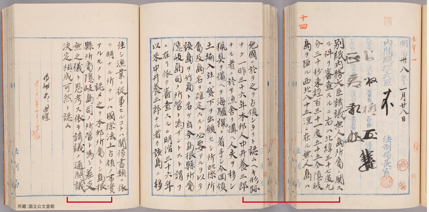
Cabinet
January 28, 1905 (Meiji 38)
[Repository] National Archives of Japan
Excerpt
The matter of the jurisdiction of uninhabited island (text omitted). The uninhabited island, located at 37°9'30" North, 131°55' East, and 85 nautical miles northwest of the Oki Islands, has no trace of occupation by any other states, and the year before last, in 1903 (Meiji 36), (text omitted) we recognize the occupation under international law, and therefore we consider that there would be no obstacle to regard the island as belonging to Japan and to place it under the jurisdiction of the Director of the Oki Island Branch Office of the Shimane Prefectural Government.
| Takeshima - Top |