Senkaku Islands under administration by the US and the return of Okinawa
September 1945 –
Initiation of the administration over Okinawa by the US Military Government
On September 7, 1945, by the signature of the Instrument of Surrender in the Ryukyu islands, the occupational administration by the US Military Government of the Ryukyu Islands started over the Nansei Islands south of 30 degree latitude. The Amami Islands, Okinawa Island and the Sakishima Islands were under military administration, in which the administrative organization was established, centering on the Okinawa Civilian Administration consisting of local residents. This represented no change from the prewar time, in that the Senkaku Islands still belonged to Ishigaki Town (City).
September 1945 / April 1952
Establishment of US Civil Administration of the Ryukyu Islands and the Ryukyu Government
In August 1950, the US Military Government established the island governments of Amami, Okinawa, Miyako and Yaeyama, and set the boundary of administration. In December, the US Military Government was reorganized as the US Civil Administration of the Ryukyu Islands (USCAR), and in 1952, USCAR abolished each island government and reorganized them into the organization shown in the chart (below).
USCAR: United States Civil Administration of the Ryukyu Islands
April 1952
The San Francisco Peace Treaty enters into effect, and Okinawa is formally placed under administration by the US
With the entry-into-effect of the San Francisco Peace Treaty, the Ryukyu Islands were formally placed under the administration by US, as “Nansei Shoto south of 29° north latitude.”
CHAPTER II
TERRITORY
Japan will concur in any proposal of the United States to the United Nations to place under its trusteeship system, with the United States as the sole administering authority, Nansei Shoto south of 29° north latitude (including the Ryukyu Islands and the Daito Islands), Nanpo Shoto south of Sofu Gan (including the Bonin Islands, Rosario Island and the Volcano Islands) and Parece Vela and Marcus Island. Pending the making of such a proposal and affirmative action thereon, the United States will have the right to exercise all and any powers of administration, legislation and jurisdiction over the territory and inhabitants of these islands, including their territorial sea.
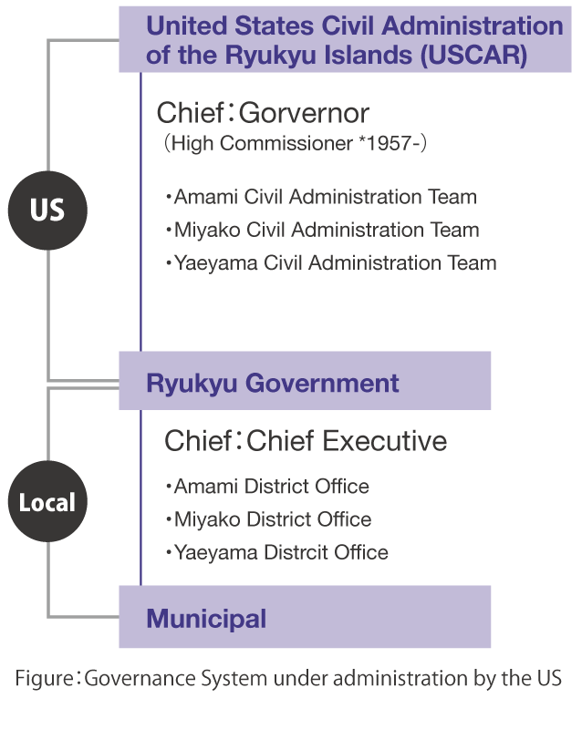
Figure:Governance System under administration by the US
1952 -
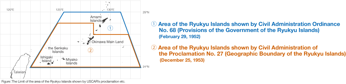
Ordinances by the US Civil Administration of the Ryukyu Islands (USCAR) include the Senkaku Islands in the area of Ryukyu No.4-5
After the establishment of USCAR (see left chart), the US (US Forces) indicated the limit of the area of the Ryukyu Islands under its administration by latitude and longitude in Ordinance No.68 (Provisions of the Government of the Ryukyu Islands) and other documents. The Senkaku Islands were always included in the area under the administration. The Islands were consistently treated as part of the Nansei Islands.
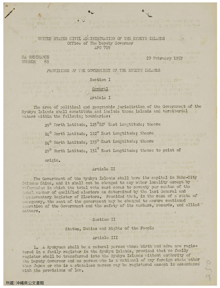
USCAR Ordinance No. 68
(Provisions of the Government of the
Ryukyu Islands)
Article 1 defines the geographic limitation of Ryukyu by latitude and longitude.
USCAR Office of the Deputy Governor
February 29, 1952 (Showa 27)
[Repository] Okinawa Prefectural Archives
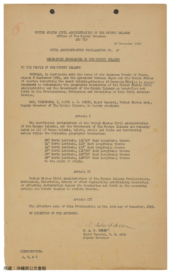
USCAR Proclamation No. 27
(Geographical limit of the Ryukyu Islands)
Article 1 defines the geographic limitation of Ryukyu by latitude and longitude.
USCAR Office of The Deputy Governor
December 25, 1953 (Showa 28)
[Repository] Okinawa Prefectural Archives
Cases demonstrating that the US (US Forces) was executing administration over the Senkaku Islands
1948
The US Military Government in Ryukyu designates Kuba Island as a bombing range No.1
The US military command designated Kuba Island and the area within a 5 mile radius as a permanent danger area (bombing range), and requested, through the US Military Government, that the Okinawa Civilian Administration notify all the people concerned.
The US included the Senkaku Islands in the area of the Ryukyu Islands from the time of the war No.2-3
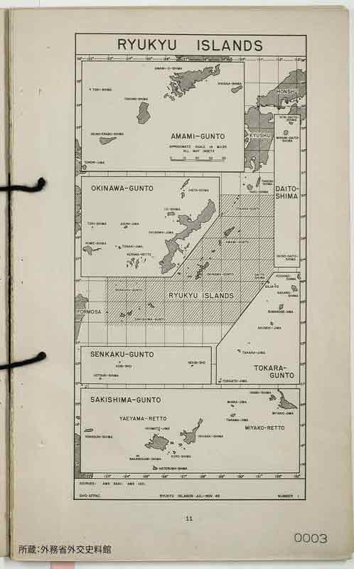
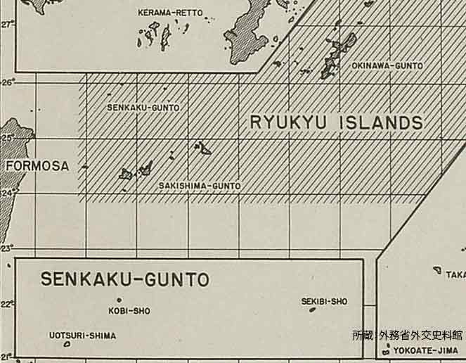
The first activity report by the United States Military Government (Issued in July 1946: Refer to chart on the right) depicted the Senkaku Islands as “SENKAKU-GUNTO,” as a part of the Ryukyu Islands. After that, the relevant ordinances and other documents continued to indicate the Senkaku Islands as being in the area of the Ryukyu Islands. Moreover, it is confirmed by documents such as the Monograph on Japan made by the Information Office of the US Navy and the Gazetteer that the US Forces recognized the Senkaku Islands as part of the Ryukyu Islands already at the time of war. This recognition continued until the return of Okinawa.
Designation of Permanent Danger Areas by the U.S. military command in Ryukyu
Excerpt
RYCOM
0830 April 9
Commanding Officer, Transportation Service
Deputy Commander, Military Government
To: Governor of Okinawa
1. The following are permanent danger areas in use by the 1st Air Division:
a. Range Number 1: 25° 56’ N, 123° 41’ E
(Kobi Sho, within a 5 mile radius)
(text omitted)
3. Request the above information be notified to all the people concerned under your jurisdiction.
(text omitted)
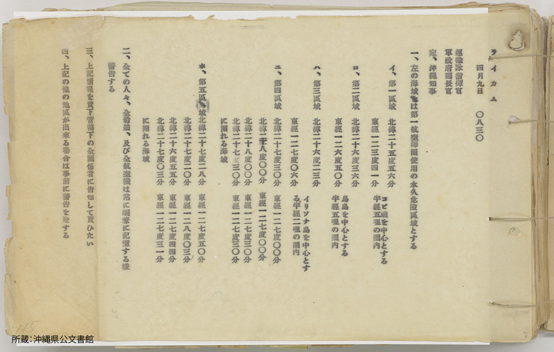
Document Section, Liaison and Public Affairs Division, General Affairs Department, the Government of the Ryukyu Islands
April 9, 1948 (Showa 23) [Repository] Okinawa Prefectural Archives
Summation of US Military Government Activities in the Ryukyu Islands No.1
SENKAKU-GUNTO in the area of the Ryukyu Islands
SUMMATION of UNITED STATES ARMY MILITARY GOVERNMENT ACTIVITIES in the RYUKYU ISLANDS No1
SUMMATION of UNITED STATES ARMY MILITARY GOVERNMENT ACTIVITIES in the RYUKYU ISLANDS No1
July-November 1946 (Showa 21)
[Repository] Diplomatic Archives of the Ministry of Foreign Affairs of Japan
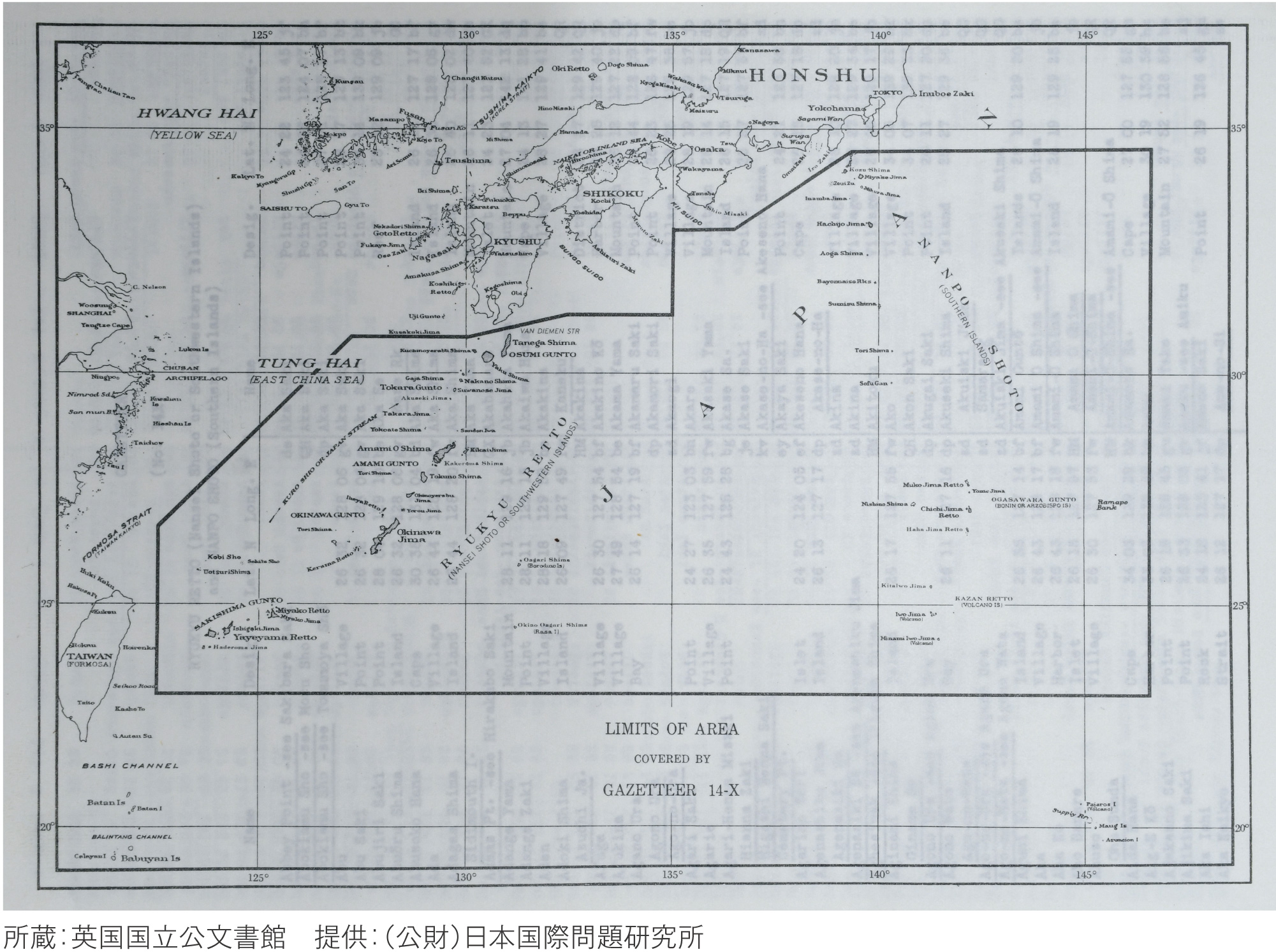
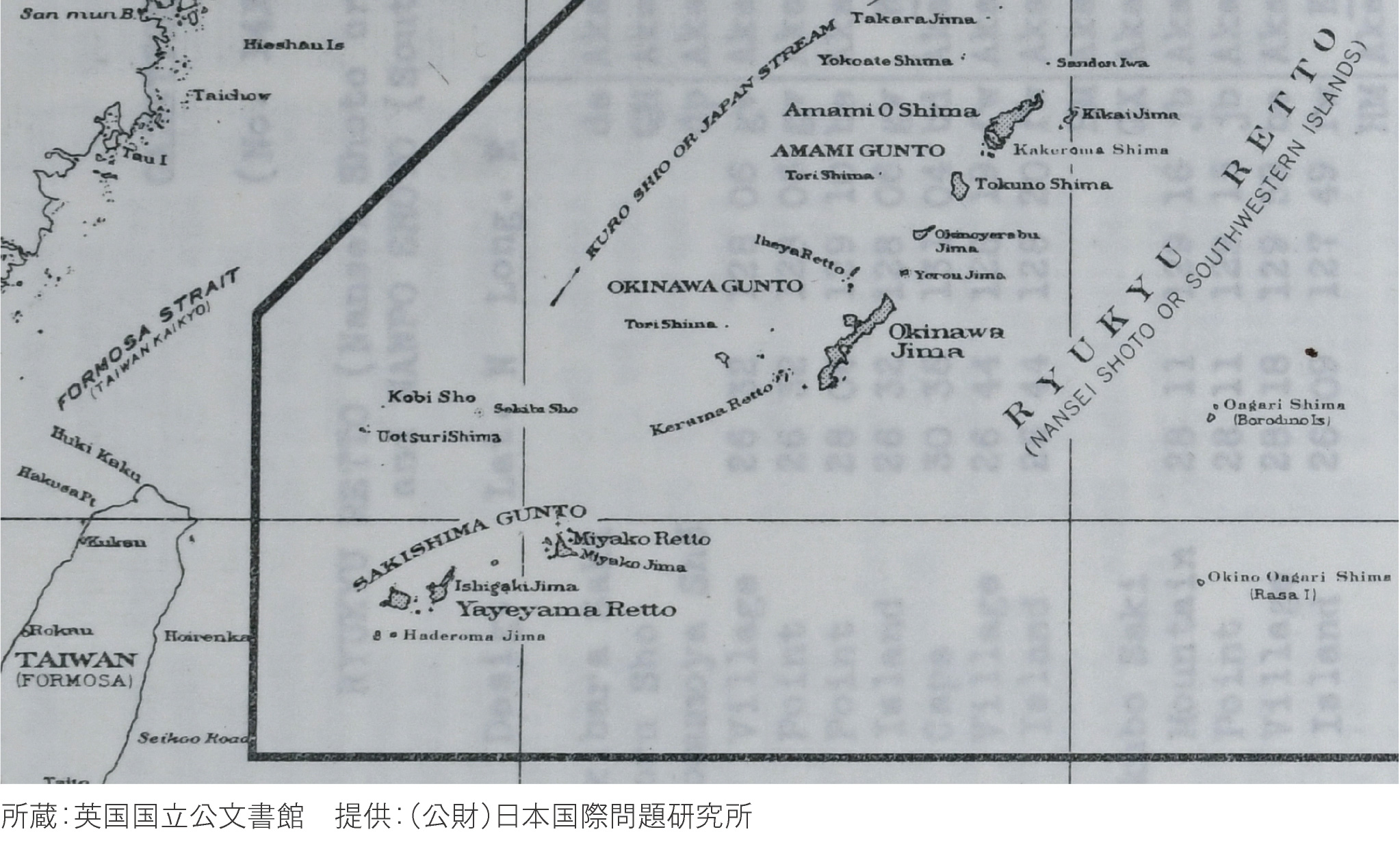
Gazetteer: The Ryukyu Islands and the Nanpo Islands
The Senkaku Islands in the area of the Ryukyu Islands
GAZETTEER No.14X RYUKYU RETTO AND NANPO SHOTO
Hydrographic Office, United States Navy Department
November 1944 (Showa 19)
[Repository] The National Archives, UK
[Contribution] Japan Institute of International Affairs
1950s
The US Forces conclude land-lease contracts for military reserve with the land-owner of Kuba Island No.6
Kuba Island, designated as a bombing range, was owned by Zenji Koga from the time prior to the war. The US Forces were required to lease the island as a military reservation. In 1958, the US concluded a comprehensive lease agreement with the Government of the Ryukyu Islands for the land used by the US Forces. At this time, many land-lease contracts were concluded for land for use by the US Forces, including Kuba Island.
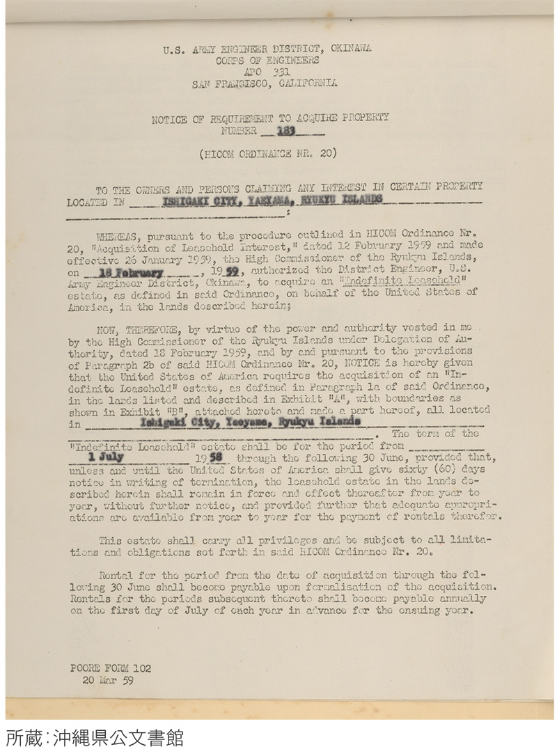
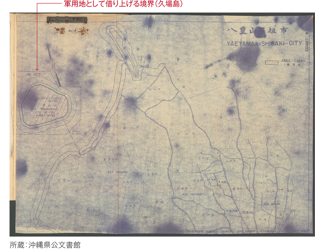
Notice of Requirement to Acquire Property, Ishigaki City
Outline
This document is a notification that the US made a request to the Government of the Ryukyu Islands for the acquisition of Kuba Island, located in Ishigaki City, for a military reservation on an indefinite lease. In the notification, the period for the start of the acquisition through the lease was to be set retroactively to July 1958. As requested in the notice, an agreement was concluded between the Government of the Ryukyu Islands and Zenji Koga, the owner of Kuba Island. This notice is attached with papers and maps that indicated the land to be acquired.
General Affairs Section of the Military Land Office, Legal Affairs Department, Government of the Ryukyu Islands
January 1960 (Showa 35)
[Repository] Okinawa Prefectural Archives
Fisheries activities and academic surveys around the Senkaku Islands
Academic research after the war started on fishing boats headed for the Senkaku Islands
In 1950, the late Tetsuo Takara (from Ishigaki Island, former President of the University of the Ryukyus, Doctor in Agriculture) travelled to Uotsuri Island and conducted the first academic survey after the war, embarking on bonito-fishing boats headed for the Senkaku Islands.
After that, Prof. Takara conducted academic survey trips to the Senkaku Islands in 1952, 1953, 1963 and 1968 with research corps including local researchers who were mainly from the University of the Ryukyus. Further academic surveys were conducted in 1971 by the University of the Ryukyus, and in 1979 by Okinawa Development Agency, contributing to the accumulation of academic knowledge, including the discovery of indigenous species of albatross and other animals and plants.
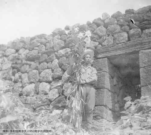
Tetsuo Takara collecting a sample of Easter lily at the former site of the dried-bonito factory in Uotsuri Island
Photo by Shinjun Tawada (1952)
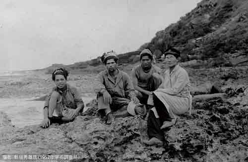
On the beach at Uotsuri Island,
Hideo Aragaki and crew members of Kihon-maru, a fishing boat
Photo by Hideo Arakaki (1952)