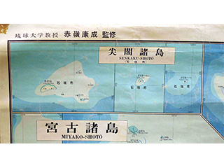
Latest Complete Map of Okinawa
The Senkaku Islands (Ishigaki City) > Uotsuri-Jima (Island) / Kita-Kojima (Island) / Minami-Kojima (Island) / Tobise / Okinokitaiwa / Okinominamiiwa / Kobi-Shō (Kuba Island) / Sekibi-Shō (Taisho Island)
Content
Latest Complete Map of Okinawa
| Document title | Latest Complete Map of Okinawa |
|---|---|
| Date created (Western calendar) | October, 1967 |
| Date created (Japanese era) | October, Showa 42 |
| Author(s) / Editor(s) | Ryukyu Bunkyo Tosho, eds. / Kosei AKAMINE, sup. ed. |
| Publisher | Ryukyu Bunkyo Tosho |
| Name of publication | |
| Content | A complete map of the Okinawa Islands (Okinawa Prefecture). Scroll. The Senkaku Islands are marked as an administrative division (of Ishigaki City). As the rough map of Nansei Islands, the Islands are drawn from Kagoshima Prefecture in southern Kyushu to the Tokara Islands, Amami Islands, Okinawa Islands, Miyako Islands, Yaeyama Islands and northern Taiwan, with the border between Taiwan and the Senkaku Islands drawn as a red line. |
| Language | Japanese |
|---|---|
| Public access | Open |
| Repository | Okinawa Prefectural Library (Japanese Only) |
| Medium | Cloth/Map |
| Copies | 8 |
| Reference No. | S1967100000103 |
| Reference & information | Follow the instruction at the Okinawa Prefectural Library |
| Notes |

