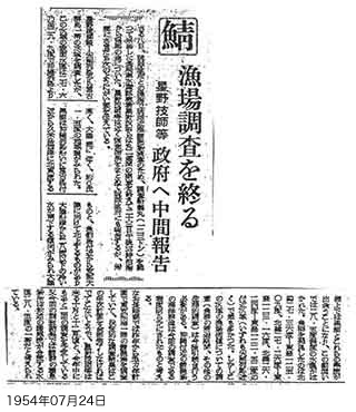
Conclusion of mackerel fishing ground survey
Engineer Hoshino, et al.
Interim report to the government
As told by Engineer Hoshino:
We surveyed the whole sea area from the Senkaku Islands to the Miyako Islands. The surface water temperature in this area was between 27.6 and 29.9 degrees, higher than the Okinawa Islands but lower than the continental shelf, with a regional difference of about 1.5 degrees centigrade.
The Kuroshio current flows partly northeast along the Okinawa Islands from near Miyakojima to the west coast of Kumejima Island, and partly northward from near Uotsuri Island toward the Chinese mainland. A tendency was seen for cold water of 28 degrees or less to flow southward from the mainland coast. These cold flows meeting the Kuroshio on the continental shelf. A water temperature of around 28.5 degrees was measured at this oceanic front. Shoals of fish were found to be most numerous in sea areas near 27.36 N 125.09 E, 27.26 N 123.16 E, and 26.24 N 122.52 E (all near the Senkaku Islands).
(part omitted)
Content
Conclusion of mackerel fishing ground survey (Okinawa Times)
| Document title | Conclusion of mackerel fishing ground survey (Okinawa Times) |
|---|---|
| Date created (Western calendar) | July 24, 1954 |
| Date created (Japanese era) | July 24, Showa 29 |
| Author(s) / Editor(s) | |
| Publisher | Okinawa Times |
| Name of publication | Okinawa Times |
| Content | Results of a survey of mackerel fishing grounds in Okinawa's coastal waters by the Tsuru Maru research vessel of the Nagasaki Prefecture Fisheries Experimental Station. Numerous shoals of mackerel were confirmed in coastal waters of the Senkaku Islands. |
| Language | Japanese |
|---|---|
| Public access | Open |
| Repository | Okinawa Prefectural Library (Japanese Only) |
| Medium | Paper, microfilm reproduction |
| Copies | 1 |
| Reference No. | S1954072400102 |
| How to access | Follow the licensing procedure at Okinawa Prefectural Library. |
| Notes |

