
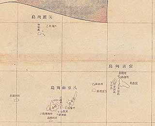
Yaeyama County, Okinawa Prefecture
Uotsuri Island, Tonoshiro Village, Ohama Magiri
Kita Kojima Island and Minami Kojima Island, Tonoshiro Village, Ohama Magir
Kuba Island, Tonoshiro Village, Ohama Magiri
(part omitted)
Printed February 20, 1906
Published February 20, 1906
Content
Complete Map of Okinawa Prefecture (1906)
| Document title | Complete Map of Okinawa Prefecture (1906) |
|---|---|
| Date created (Western calendar) | February 1906 |
| Date created (Japanese era) | February, Meiji 39 |
| Author(s) / Editor(s) | Okinawa Prefectural Government |
| Publisher | Kinkodo Shoseki |
| Name of publication | |
| Content | This map was compiled by the Okinawa Prefectural Government after the land consolidation projects were completed, and was published by Kinkodo in 1906. On the map, the Senkaku Islands are printed as "Senkaku Islands", and the various Senkaku Islands are marked as "Uotsuri Island, Tonoshiro Village, Ohama Magiri", "Kuba Island, Tonoshiro Village, Ohama Magiri" and "Kita Kojima Island and Minami Kojima Island, Tonoshiro Village, Ohama Magiri". |
| Language | Japanese |
|---|---|
| Public access | Open |
| Repository | Okinawa Prefectural Library (Japanese Only) |
| Medium | Paper / Digital data |
| Copies | 2 |
| Reference No. | S1906020000103 |
| How to access | Follow the licensing procedure at Okinawa Prefectural Library. |
| Notes |