
Content
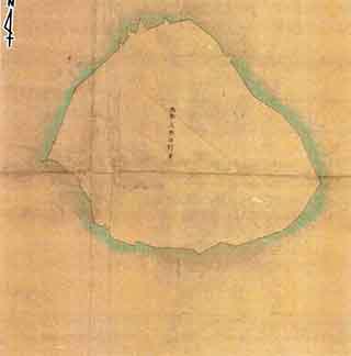
Cadastral Map Tonoshiro, Ishigaki City, Okinawa Prefecture Kubashima (Kuba Island)
| Related archives | S1902120000101 |
|---|
| Document title | Cadastral Map Tonoshiro, Ishigaki City, Okinawa Prefecture Kubashima (Kuba Island) |
|---|---|
| Date created (Western calendar) | (1902) |
| Date created (Japanese era) | (Meiji 35) |
| Author(s) / Editor(s) | |
| Publisher | Naha Regional Legal Affairs Bureau, Ishigaki Branch |
| Name of publication | |
| Content | This is the Senkaku Islands / Kubashima (Kuba Island) portion of the "Cadastral Map", forming a pair with the "Complete Map of Tonoshiro Village, Ohama Magiri, Yaeyama County" (Land Cosolidation Map Senkaku Islands) held in the archives of Ishigaki City History Editorial Department. The land lot number given to Kubashima (Kuba Island) on the "Cadastral Map" is "2393" (moorland). The lot numbers of other islands on the map are Minami Kojima Island "2390", Kita Kojima Island "2391" and Uotsuri Island "2392". |
| Language | Japanese |
|---|---|
| Public access | Closed |
| Repository | Naha Regional Legal Affairs Bureau, Ishigaki Branch (Japanese Only) |
| Medium | Paper |
| Copies | 1 |
| Reference No. | S1902000000301 |
| How to access | |
| Notes |