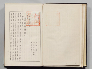
The country of Chōsen (Joseon) is on the east side of Asia. Its geographic features is a long and narrow, large peninsula surrounded by islands. Its location is from 33°15’N to 42°25’N and from 124°30’E to 130°35’E.
Content
Vol. 2 "Kan-ei Hydrographic Publication"
| Document title | Vol. 2 "Kan-ei Hydrographic Publication" |
|---|---|
| Date created (Western calendar) | April, 1883 |
| Date created (Japanese era) | April, Meiji 16 |
| Author(s) / Editor(s) | Hydrographic Bureau, Imperial Navy |
| Publisher | Hydrographic Bureau, Imperial Navy |
| Name of publication | |
| Content | The 1st edition of Hydrographic Publication of Korean and Russian coast. In the Part 5 (of the publication), the "Liancourt" rocks (present-day Takeshima) and "Utsuryo Island (Ulleungdo), another name of Matsushima and the western name of Dagelet" are listed as sunken rocks or hazardous reefs in the Sea of Japan. It indicates that the eastern tip (end) of Chōsen (Joseon) is at 130°35' east longitude, which is west of Takeshima. |
| Language | Japanese |
|---|---|
| Public access | Open |
| Repository | National Archives of Japan |
| Medium | Paper |
| Copies | 6 pages |
| Reference No. | T1883040000101 |
| Reference & Information | Follow the instruction at National Archives of Japan |
| Notes |


