
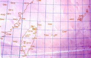
*Reference: Observation point numbers
929 = Okinawa Main Island, Naha
927 = Miyakojima
918 = Ishigaki Island
912 = Yonaguni Island
916 = Uotsuri Island
Content
Far East Weather Maps (FY1955 edition)
| Document title | Far East Weather Maps (FY1955 edition) |
|---|---|
| Date created (Western calendar) | 1955 |
| Date created (Japanese era) | Showa 30 |
| Author(s) / Editor(s) | Japan Meteorological Agency |
| Publisher | |
| Name of publication | |
| Content | Forecast weather map Form No.3 Observation point No.916 is printed in the location of Uotsuri Island. |
| Language | Japanese |
|---|---|
| Public access | Open |
| Repository | Okinawa Prefectural Archives |
| Medium | Paper |
| Copies | 5 |
| Reference No. | S1955000000101 |
| How to access | Follow the licensing procedure at Okinawa Prefectural Archives. |
| Notes |