
Content
| Document title | Survey map of distances within Okinawa Prefecture (Ryukyu Shimpo) |
|---|---|
| Date created (Western calendar) | April 1914 |
| Date created (Japanese era) | April, Taisho 3 |
| Author(s) / Editor(s) | Ryukyu Shimpo |
| Publisher | Ryukyu Shimpo |
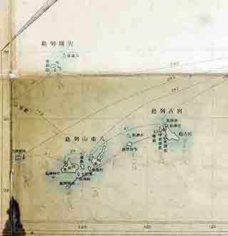
| Name of publication | Survey map of distances within Okinawa Prefecture |
| Content | A supplement to the 5,000th edition of the Ryukyu Shimpo newspaper. Distance from Naha Port on Okinawa Main Island to Uotsuri Island in the Senkaku Islands: 230 nautical miles. |
| Language | Japanese |
|---|---|
| Public access | Open |
| Repository | Okinawa Prefectural Library (Japanese Only) |
| Medium | Paper / Digital data |
| Copies | 1 |
| Reference No. | S1914040000103 |
| How to access | Follow the licensing procedure at Okinawa Prefectural Library. |
| Notes |