| Document title |
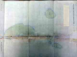
Complete Map of Tonoshiro Village, Ohama Magiri, Yaeyama County / "Land Consolidation Map - the Senkaku Islands" |
| Date created (Western calendar) |
December 1902 |
| Date created (Japanese era) |
December, Meiji 35 |
| Author(s) / Editor(s) |
Toma Tsuguo |
| Publisher |
Provisional Okinawa Prefecture Land Consolidation Secretariat |
| Name of publication |
Complete Map of Tonoshiro Village, Ohama Magiri, Yaeyama County / "Land Consolidation Map - the Senkaku Islands" |
| Content |
The Okinawa Prefecture Land Consolidation Act was enacted in 1899, and the Provisional Okinawa Prefecture Land Consolidation Secretariat was established on the basis of this Act. It carried out land consolidation projects (surveying and land tax revision) in the prefecture, completing projects for Okinawa Island in 1903 and for the Miyako and Yaeyama Islands in 1902. A land consolidation project was also carried out in the Senkaku Islands. The map, which was created based upon the anycome of the result of the surrey on the Islands, has a reference to "December, 1902 Provisional Okinawa Prefecture Land Consolidation Secretariat Mapping, Temporary Staff Toma Tsuguo". |